CHARLOTTE, N.C. — A major storm will begin surging through the Charlotte area today, Monday, developing to the southwest and gradually pushing moisture into the area as the day progresses. Monday will start off dry and snow will make make it’s way into the mountain areas during the late morning and early afternoon.
Toward the late afternoon snow will develop across the entire area. Charlotte will see a quick burst of snow during the late afternoon and evening. Snow will quickly change to sleet and freezing rain and develop into the overnight. Icy conditions will be a major concern, creating dangerous conditions. 1 inch of snow and sleet is possible with a quarter inch of ice.
Temperatures will remain at or below freezing with high of 32 on Monday.
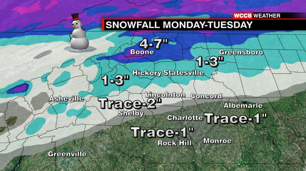
Areas north of Charlotte, Ashville-Hickory-Statesville, will endure a longer duration of snow and sleet before a changeover to freezing rain. These areas could can expect 3-5 inches with a tenth of an inch of possible ice.
In the mountain region, elevations over 3,000 feet, will likely see just snow. 5-8 inches of snow can be expected in these areas with elevations over 5,000 feet possibly seeing up to 10 inches.
Expect this storm to linger into Monday night before tapering off Tuesday.