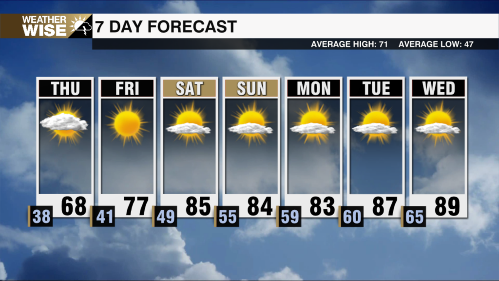
Showers Return Today, Storms Friday
The pleasant, dry fall air we’ve all enjoyed will be replaced by a more muggy air mass today as what’s left Beta brings showers to the region. Cloudy skies with highs only reaching the mid-70s. A few showers will begin across the higher elevations earlier in the day, but the majority of the area won’t get in on the rain until tonight. Rain and a few storms possible for Friday with temps reaching the mid-70s. Rain will gradually clear out with 1-2″ of rainfall possible for the mountains, making localized flooding a threat with any heavy, longer-lasting downpours. Shouldn’t see a flooding threat for the Piedmont with 1/2″ of rainfall likely. The weekend will bring warmer temps with highs reaching the low 80s. Isolated evening storm chances will be possible through early next week. Cooler, drier air will bring back those fall feels by the middle of the next work week.
Today: PM Showers. High: 74 Wind: SW 5 mph
Tonight: Showers Likely. Low: 61 Wind: NE 5 mph
Fri: Showers/Storms. High: 74 Wind: S 5 mph
Fri PM: Chance Showers. Low: 64