Winter Weather Alert: Latest on Freezing Temps and Snowfall Totals
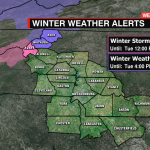
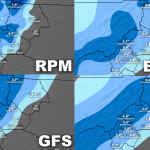
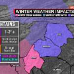
The first significant snow accumulation for the mountains will arrive Monday through early Tuesday afternoon for the mountains. A Winter Weather Advisory for Ashe and Watauga counties and a Winter Storm Warning for Avery county are in place ahead of the snow and blustery conditions. The low-pressure system that helped bring in showers and a few storms overnight and this morning will continue progressing towards the northeast allowing a cold front to bring in much colder air to the area this afternoon through Tuesday.
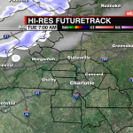
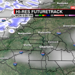
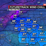
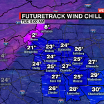
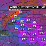
Snow showers will begin this afternoon for the mountains. A few heavy bands of snow will be possible with accumulations of 1-2″ likely for areas around 3500′. Higher elevations (Beech Mountain, Banner Elk, Meat Camp, etc) will likely see snowfall totals exceeding 3″. This combined with strong northwesterly winds where gusts could exceed 40mph will not just make for a blustery 24-36 hours, but also cause dangerous driving conditions by reducing visibility. Temps will drop in the teens and 20 overnight for the mountains, but it will likely feel like the single digits with the wind chill. Remember to bring your pets inside and stay off the roads if you can.
A few stray showers may be possible across the Foothills and Piedmont, but likely drier air will cut off precip chances. Temps will be the coldest of the season with lows dropping into the 20s and 30s overnight (wind chills will make it feel like the teens and 20s). Daytime highs will not get out of the 40s Tuesday, but with that northwesterly wind, it will feel more like the 30s for much of the day. The wind will gradually calm, but temps will be freezing Tuesday night area-wide with widespread frost likely.