Winter Storm Warning for the Mountains Wednesday Night
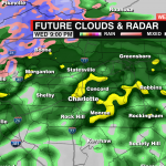
 Rain will become widespread through the evening hours of Wednesday. Cold air is rushing in behind the moisture which will allow areas north of I-40 to be in the sweet spot for a changeover from rain to snow.
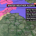
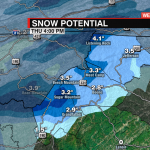
 A winter storm warning will go into effect from 6pm until noon Thursday. Up to half a foot of snow will be possible for the highest elevations. Areas below 3500′ will pick up 1-3″ of snow overnight.
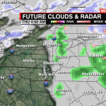
We could get a few flakes across the foothills and northern Piedmont, but an accumulation is unlikely. Expect a trace to an inch at most across the northwestern Piedmont. While the Triad and eastward is looking at 1-3”, Charlotte may be in on the short end of the stick in terms of snow. Much of the cold air entrenched in this system won’t dive far enough south, leaving the Queen City with a cold, disappointing rain. Snow will taper off west-to-east early Thursday.

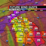
Strong winds will also be a concern. Winds will pick up tonight with gusts 40-50 mph possible for the mountains. This will make for a blustery Thursday with wind chills in the single digits and teens through Thursday.