Cold and Rainy Valentine’s Day Weekend

Friday


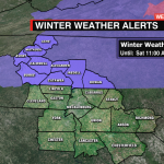
We’re now stuck in a cold, messy pattern. The coldest air sits just north and east of us. Not cold enough for snow, but chilly enough Disturbance along the coast will trigger rounds of rain through the weekend. Rain/freezing rain will wrap this morning. Highs won’t get out of the upper 30s/low 40s. Rain returns tonight from the south. Winter Weather Advisories in effect for folks north of I-40. As cold temps settle in this evening, we will likely be dealing with freezing rain to start for our northern communities.
Weekend


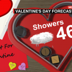
By late morning Saturday this will change to a cold rain areawide. Temps once again will remain chilly, as rain and showers stretch into the night. Valentine’s Day brings more showers, after a brief lull in the rain in the morning. Highs will reach the mid 40s.
Next Week


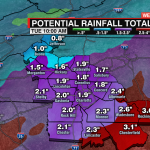
Cold front will clear out the cold next week, allowing highs to get back into the mid to upper 50s starting Tuesday, but, more rain follows. We could see a dry day Wednesday, but it will be short lived with more showers and wintry weather to end the week.
Download our Weather App

Download the WCCB Weather App for all the latest information: wccbtv.com/wxapp