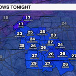
Icy Spots Will Develop As Temps Fall Monday Night
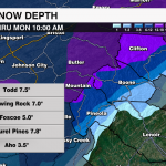
A low-pressure system swung through the area early Monday morning bringing whiteout conditions to the mountains and even a few wet flakes as far south as the I-85 corridor. More than 6″ of snow fell across the higher elevations with heavy rain causing localized flooding through Piedmont.

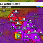
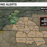
More than 200,000 were left without power across the Carolinas as winds gusted more than 50 mph.
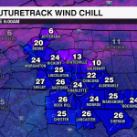
Temperatures are expected to fall into the mid-20s across the Piedmont and into the teens in the Mountains overnight. Thankfully, the wind and sun will continue to dry out roads across the Piedmont, but areas with snow accumulation will see a refreezing overnight. Black ice is expected in the Mountains and Foothills.

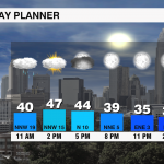
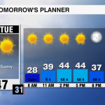
Make sure you are taking it extra slow if you must be out on the roads to avoid any icy areas – especially while traveling across elevated surfaces like bridges and overpasses. Temps will be slow to warm Tuesday with highs struggling to reach the upper 40s through the afternoon. Refreezing will likely remain a problem for the mountains as snow begins to melt Tuesday with black ice likely through mid-week until the snow is able to melt. Another system will swing across the Carolinas late Thursday which will bring a rain to snow transition for the Mountains.


