Winter Storm Impacts Move East
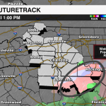
The cold front that is moving through the Carolinas this morning will settle well east of the Carolina coast, which will keep this moisture-starved, weak disturbance’s worst impacts close to the coast. That being said light sleet/snow will be possible early Friday, but the onset of more steady straight snow showers for the areas mentioned will begin Friday evening after 4 pm and will end by midnight. Accumulations will be less than an inch with not much more than a flurry outside of that zone. The biggest threat will be slippery roads through Saturday morning. Cold and dry weekend with temps struggling to break out of the 30s Saturday and mid-40s Sunday.
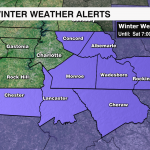
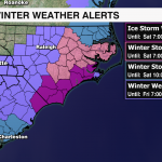
WHAT: Winter Weather Advisory
TIMING: Some sleet/freezing rain is possible early Friday, but accumulating snow will be 4pm-midnight
TOTALS: <1″ south and east of I-85, with light ice accumulation
IMPACTS: Slick Travel, Black Ice


