Localized Flooding Threat, Isolated Severe Storms Possible Monday
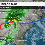
The National Hurricane Center issued the first tropical outlook 10 days ahead of the official start of the 2022 Atlantic Hurricane Season. The center of this low moved inland over Pensacola early Monday morning meaning this won’t become our first named storm of the season. However, this disturbance will still be funneling tropical moisture to the southeast bringing heavy rain and storms to the region to start the workweek.
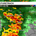
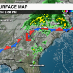
A boundary that brought scattered storms to the region late Sunday has stalled just south of the area. The tropical low will track north into the Carolinas through the afternoon bringing more rain and storms to the area shortly after lunchtime.

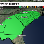
The Storm Prediction Center has highlighted much of the area under a level 1 severe threat. Damaging wind and an isolated tornado will be possible – especially for areas south and east of I-85 where we get some peeks of sunshine going into the afternoon. A wedge will be building into the region keeping cloudy skies, patchy fog and cooler temps for the rest of the region which should limit the severe threat for the mountains into the I-40 corridor.

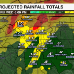
The biggest threat across the region will be localized flooding. Rainfall totals of 1-2″ will be possible across the Piedmont into the foothills. Up to 3″ of rainfall will be possible for the higher elevations. We have been pretty dry over the last few weeks with drought conditions returning to the higher elevations with the latest drought outlook. However, any storms that train could bring a lot of heavy rain in a short period of time increasing the flooding threat for poor drainage and flood-prone areas.

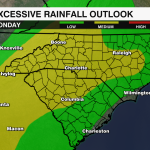
Rain and storm chances will continue into early Tuesday with isolated storms possible Wednesday. A strong cold front will barrel through the region late in the week. This will bring another shot of rain and storms to the region with a few strong to even severe storms possible. These storms could also lead to more localized flooding and will be something we need to watch very closely through the end of the week.