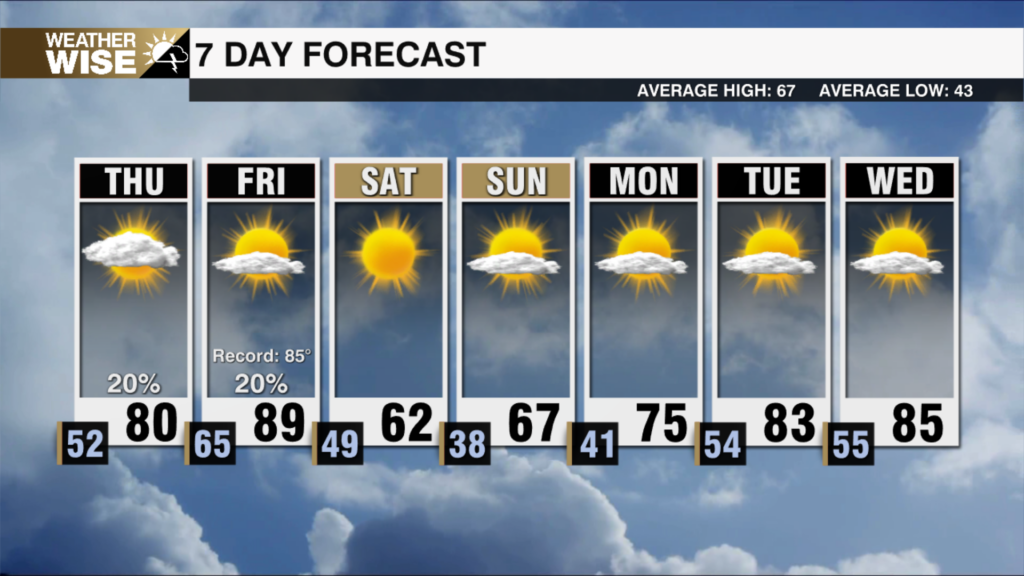
Beautiful Close to Workweek, Start to Weekend
Temperatures will warm close to 80° by Sunday, but another cold front will stop any recovery dead in its tracks next week.
Happy Friday Junior! After a muggy start to our Thursday, a passing cold front will filter cooler and drier air into the Carolinas as we head into the weekend. Friday morning’s lows will bottom out in the 30s and 40s across the board. Expect highs near average in the 60s and 70s as we close out the workweek. A steady warm-up will build through the weekend as winds return out of the south and west. Piedmont highs will approach 80° both Saturday and Sunday before big changes arrive.
A powerful cold front originating from northwest Canada will plow through the Southeast by Monday. Rain chances don’t look especially high, but a few showers are possible Sunday night into Monday. Regardless, the bigger story will be the colder air behind it. Near-freezing temperatures are in the forecast around the western half of the Carolinas by Wednesday morning. Now is the time to get your garden prepped for the potential frost.
Tonight: Clearing out. Cooling down. Low: 47°. Wind: NW 5-10.
Friday: Beautiful. High: 74°. Wind: SW 5-10.
Friday Night: Clear and cool. Low: 47°. Wind: SW 5-10.
Saturday: Another lovely day. Warmer. High: 80°. Wind: SW 5-15.