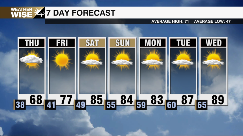
Soupy & Warmer Thursday
AM Headlines
- Pretty much done with the rain this AM
- Warmer, and feeling more muggy today
- Breezy for Mountains = bad for leaves..
- Front moves through late – isolated showers/storms
- Cooler and drier air moves in overnight
- Pleasant weekend
- Scattered showers/storms return Sunday into Monday
- MUCH colder next week
Discussion
Steady Rain Wrapping Up, Warmer Today Ahead of Front – Broken Line of Showers/Storms Late
Pretty much done with rain this morning as just a few scattered showers remain. Front lagging behind, but not bringing much activity to Eastern Tennesse. Temps will warm ahead of the front with highs reaching the upper 70s this afternoon after starting the morning in the 60s as clouds begin to thin. A line of showers and storms tries to come together ahead of the front late today, but rain chances remain minimal for the area. Breezy across the mountains with gusts 20-25 mph today/tonight. This could bring down some leaves before the weekend peepers make it for the last decent weekend of checking out the fall colors in the high country.
Pleasant Fall Weekend
Temps cool significantly overnight as drier air slides into the region. Lows will fall into the 30s for the high country and 40s across Piedmont. Highs will be a few degrees below average, reaching the low 70s under sunny skies. Beautiful weekend coming up. Highs will reach the upper 70s Saturday and Sunday.
Next Cold Front Brings BIG blast of Cold Air
Another cold front takes aim at the area late Sunday into Monday. Significant rain chances not looking too great, but boy will this bring on the chill next week. Highs will struggle to break out of the 50s Tuesday with patchy frost stretching into the Piedmont Wednesday as lows bottom out in the 30s.
Tropics Update
TS Karl
Sitting nearly stationary. It will move south today toward Tabasco and Veracruz. It will begin to weaken as it approaches the Bay of Campeche Friday. Flash flooding and mudslides will be the biggest threat with 3-7″ and up to 12″ of rain possible. Dangerous rip current risk also a concern.