Snow Totals Increase For The Mountains With Flakes Possible In The Piedmont
If you want to see snow, your best bet will be to head to western North Carolina and the High Country
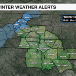


CHARLOTTE, NORTH CAROLINA — It has been 381 days since Charlotte has seen at least a trace of snow. Could we break that stretch this weekend? It is not looking likely. It is possible the Piedmont will see a burst of snow, but accumulation is not expected.
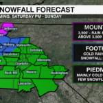
As of Friday afternoon, we can expected a cold rain in Charlotte with the possibility of a quick burst of snow. Accumulation is not expected, but some snow on the grass is *possible*. Higher snow totals are still expected across the Mountains with 6”+ possible above 5,000′.
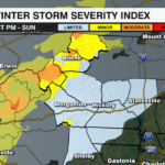
Here is our latest snowfall forecast:

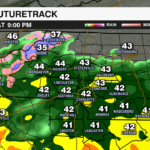
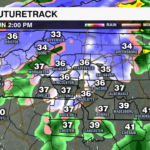
A Tricky Forecast:
We are forecasting what is called an upper level low. These bring their own cold air. Exactly how far the cold air makes it into the mid and lower levels of the atmosphere is the tricky part. Will the warm layer at the surface be shallow or deep? If it is shallow, we see snow. Right now, it is looking like temperatures across most of the Piedmont will be just above freezing around 5,000 feet meaning a snow is not likely. There are signs that a pocket of colder air at 5,000 feet will briefly develop. This could result in a quick burst of snow.
Bottom Line:
- This will be a cold rain event for Charlotte. A quick burst of snow is possible, but accumulation is not expected
- Light accumulation is possible along and around I-40. Forecasting a trace – 2”.
- Snow totals will be highest across the Mountains. The higher in elevation, the higher the totals.
IF we see snow, this would be a big wet snow. This means with surface temperatures above freezing, there should not be many problems as snow would have a tough time sticking.
Stay with the WCCB Charlotte weather team to keep you updated!


