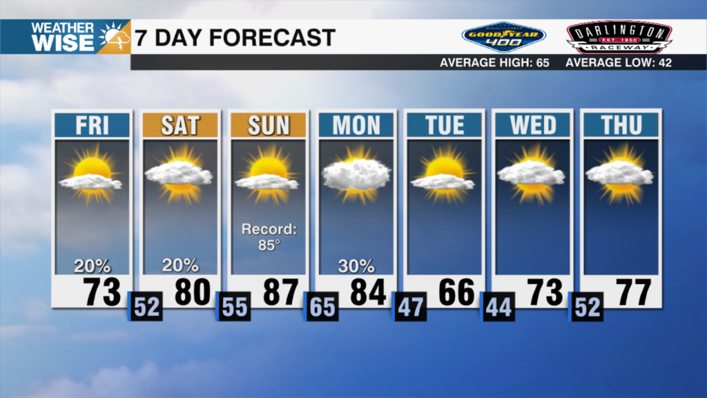
Record Max Temps Possible Today
AM Headlines:
- Record Breaking Temps Today
- Many of these records were set back in 2018
- 4th earliest 80 degree day on record possible for CLT
- Record high max and min for CLT
- 79 High Max and 59 High Min (both 2018)
- Breezy today, isolated showers possible
- Cold front brings cooler temps, rain Friday
- Wedge builds Saturday
- Cloudy & cool w/ more rain
- Temps rebound to the 70s Sunday
Discussion:
Ridge of high pressure will keep record warmth in the forecast today. We’re waking up to temps in the mid to upper 60s – a good 30 degrees above average. This will likely give us a record high minimum temp. The record is 59 set back in 2018. We’ll also be flirting with the record high set back in 2018 of 79. Highs will likely reach the low 80s, which would be the 4th earliest 80 degree day on record for Charlotte. Breezy today with winds out of the southwest 15-20 mph. A few showers possible today, but expecting more widespread rain Friday evening. Cold front will press into the region through Friday morning. Winds will transition out of the northeast. Highs will still reach the low 70s, but expect temps to drop quickly through the evening. Rain pushes in Friday night as the front stalls across the area. High pressure build over New England creating a wedge setup for the Carolinas. Expect it to be cloudy, cool and wet Saturday. Temps will fall to the mid 40s in the morning with highs only reaching the low to mid 50s during the afternoon. Rain will taper off by the early evening. Temps rebound to the low 70s by Sunday.