‘Ring Of Fire’ Weather Pattern Brings Severe Weather Threat To The Carolinas
The ring of fire is an atmospheric pattern associated with thunderstorms and high heat
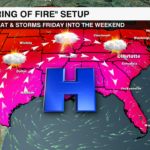
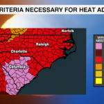
CHARLOTTE, NORTH CAROLINA — A heat wave has been baking the southern half of the country for more than two weeks now. A ridge of high pressure has been locked across the Deep South allowing for this oppressive heat.
When storms form around the high pressure, this is know as the ‘Ring of Fire’. This weather set up will bring the risk of isolated severe storms to the Carolinas Friday and Saturday.

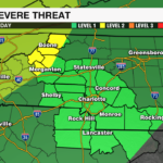
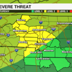
Storm Threat Level:
On Friday, the Mountains are under a ‘Slight Risk’ which is a level 2 of 5. The rest of the area is under a ‘Marginal Risk’ which is a level 1 of 5.

On Saturday, most of the area will be under the level 2 ‘Slight Risk’.

Primary Impacts:
Both Friday and Saturday, the primary threats are damaging wind and hail. The tornado threat is very low, but not totally zero.
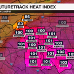
Stay weather aware and stay cool!


