Tracking Thursday’s Severe Threat
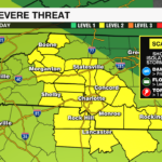
The Storm Prediction Center has expanded the level 2 (out of 5) severe threat to cover the entire region this afternoon. Storms did not make it past the blue ridge this morning allowing instability to build across the region with flooding rain for parts of the Tennessee Valley. As of 1pm, temperatures across the region are near 90 and climbing which means more instability and the potential for severe storms increases. Damaging wind and localized flooding remain the biggest threats, however, an isolated tornado cannot be ruled out.
Models have struggled to get a good handle on today’s storms, but if this cluster of storms to our west does begin to push into the region late this afternoon into the early evening then these storms will be fueled by a moist and unstable environment.
The severe threat will taper off after 10pm. Isolated storms still possible late in the day Friday. Temps will climb into the 90s. The heat index will reach the mid to upper 90s, but relief will be in sight. A cold front will bring drier air and slightly cooler temps for the weekend ahead.
Get the latest updates on today’s severe weather threat with the WCCB Weather App powered by COIT.


