Severe Thunderstorm Watch Tuesday for Parts of the Region
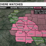
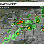
A Severe Thunderstorm Watch has been issued for most of the Piedmont through 9pm Tuesday evening. Damaging wind gusts remain the primary threat. However, heavy rain leading to localized flooding, large hail, and an isolated tornado cannot be ruled out.

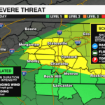
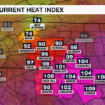
The slow moving cold front to our west has lead to a very unstable air mass over the Piedmont. Temperatures have climbed well into 90s. This in combination of tropical dew points in the mid to upper 70s has pushed heat indices well into the triple digits. A heat advisory remains in effect until 8pm for areas also under the severe thunderstorm watch. Storms have already begun to fire up north of I-85 in the wake of this morning’s storms with more storms expected through the evening as the cold front presses through the area.
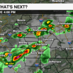
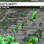
Storms will become more scattered as the afternoon progresses There is plenty of energy, moisture and moderate shear to support strong to severe storm development. We will need to watch for any storms that show signs of rotation, although the best environment to support that will be just east of the area.
If the front stalls overnight we may have a few storms linger into early Wednesday for the far eastern fringe of the area, but the severe threat will be much lower. Humidity levels will drop with the passage of the front as winds transition out of the northwest bringing in drier air and quieter weather through mid-week.
Keep up with the latest updates from the WeatherWise team by downloading the WCCB Weather App.


