Hurricane Margot Forecast to Stall
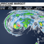
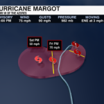
Hurricane Margot has maximum sustained winds of 75 mph and is slowly moving east/northeast at 3 mph
Margot will gradually decrease in speed and meander in the Atlantic. Steady weakening will also occur. This storm is no threat to land. 
Make sure you are staying up to date on the tropics with the WeatherWise team – download the WCCB Weather App.
Previous Update 11am 9/13
As of the 11 a.m. update from the National Hurricane Center, Margot has strengthened slightly with sustained winds of 90 mph. It is moving to the north-northwest at 7 mph.
Margot is forecast to slow by the end of the day Thursday and gradually stall this weekend with the loss of steering currents.
It will begin to weaken over the next 72 hours, however, it will likely remain a tropical storm through the weekend as it meanders over the Central Atlantic.
Swells from Margot will begin in the Azores later today. Dangerous rip currents and surf are likely for the islands over the next few days.
Previous Update 11pm 9/12
Hurricane Margot is holding onto maximum sustained winds of 85 mph. Slight fluctuation in intensity is possible over the next couple of days. 
Thankfully, Hurricane Margot will not impact the United States – it will stay out to sea.
PREVIOUS UPDATE 9/12 11AM
Hurricane Margot will strengthen over the next few days as it continues its track to the north. As of the 11am update from the National Hurricane Center, Margot has sustained winds of 85 mph with stronger gusts.

It currently is moving north at 12 mph. It will begin to turn to the north-northwest tomorrow at a slower pace, before tracking back to the north at even slower pace late in the work week.

This storm is not a threat for the US mainland, but it will kick up dangerous surf for the Azores beginning Wednesday.
PREVIOUS UPDATE 9/11 11PM
Margot strengthened into a hurricane around 5 PM ET on Monday. As of 11 PM, maximum sustained winds are up to 80 mph. This is the 5th hurricane of the 2023 Atlantic hurricane season. Additional strengthening is likely, but this will not impact the United States – it will stay out to sea.
Make sure you are staying up to date on the tropics with the WeatherWise team – download the WCCB Weather App.
PREVIOUS UPDATE 5 AM 9/11
As of the 5 a.m. Monday update from the National Hurricane Center, Tropical Storm Margot is tracking north over the open Central Atlantic Ocean. Winds are sustained at 65 mph with gusts upwards of 75 mph.

It is forecast to strengthen over the next 48 hours and will likely become a hurricane by Monday night or Tuesday morning. This would be the 5th hurricane of the 2023 Atlantic Hurricane Season.
It will likely remain at hurricane category 1 strength through the week. It will begin to weaken as it moves into the cooler waters of the north-central Atlantic by this weekend.
This storm will cause no impacts to the U.S. coast. In fact, it will have very little chance of any land interaction before it weakens this weekend.
We are now at peak hurricane season. Make sure you are staying up to date on the tropics with the WeatherWise team – download the WCCB Weather App.


