NWS: High-End EF1 Tornado Confirmed In Catawba County
North Carolina | South Carolina Severe Storm Updates and Timeline:
The National Weather Service confirms a high-end EF1 tornado touched down in Catawba County, killing a man and injuring four others. The tornado was 240 yards wide, according to NWS.
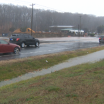
WCCB’s WeatherWise team tracked severe storms that affected the Carolinas Tuesday. The impacts of the storms resulted in flooding, road closures, fatal injuries, power outages, and damage in several counties.
As skies clear and the sun returns Duke Energy works to restore power to thousands who lost power in the mist of Tuesday’s storm.


Tornado Video:
Video provided by Catawba County News and Weather’s Facebook page shows the raw power of the storm that passed through Claremont.
*Warning: Viewer discretion is advised.
Dustin Weaver was killed and four others seriously injured when a high-end EF1 tornado hit Claremont. Click HERE for more details.
Click here to view photos of storm damage across the Carolinas
Tornado Warnings:
Tornado warnings were issued throughout the day for several counties including: Stanly County, Mecklenburg County, Union County, Anson County, and Cabarrus County.
Power Outages:
As of 6:30 p.m. Tuesday, Jan. 9th – Duke Energy had more than 141,409 customers without power across the Carolinas. As of 2pm on Wednesday, Jan. 10th 21,020 customers remained without power, according to Duke Energy.
School Delays and Closures:
Numerous school districts announced delays or closures for Wednesday, January 10th. Click HERE to see the full list.
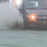
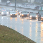
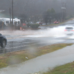
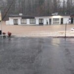
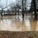
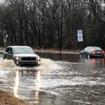
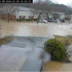
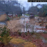
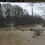
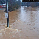
Flooding:

Briar Creek Road at Shamrock Drive at 4:29pm
Flash flood warnings have been issued throughout the Carolinas. The Charlotte-Mecklenburg Flood Information & Notification System (FINS) is reporting rain totals in the area of nearly 3 1/2 inches of rain in south Charlotte and nearly 2 inches of rain in Uptown Charlotte. Click HERE to see rain gauge totals in your area.

5 p.m.
A State of Emergency has been declared in Union County, according to the Union County Board of Commissioners. Read the full declaration HERE.
1 p.m.
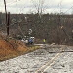
Catawba County Officials report injuries during severe weather resulting in the death of one individual and serious injuries for four others. Family members tell WCCB’s Marvin Beach, Dustin Weaver died when powerful storms passed along Evening Drive. A GoFundMe set up for Weaver’s family says he died while trying to protect his pregnant girlfriend when the strong winds hit.

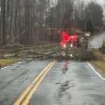
Claremont Storm Damage
For full story details click here.
12 p.m.
As severe weather progressed, the Charlotte area witnessed impacts of the storms. WCCB obtained video footage of damages after a utility pole went through a car window on Lakeside Drive in east Charlotte.
If you’d like to share a photo or video with us, please submit them to photos@wccbcharlotte.com.
5 a.m.
The period of greatest concern arrives in the early afternoon as a powerful line of severe storms develops east of the Appalachians. This line will contain the strongest winds and a considerable tornado threat, especially to the south and east of Charlotte, as it races eastward. Rain will taper off by the early evening as moisture clears northeastward. Totals will end up between 1-3″ with locally higher amounts possible, particularly to the north and west of I-85. Highs should end up in the 60s and 70s for most in the Piedmont and Foothills while the High Country stays cold in the 30s and 40s.
Every public school in the Foothills and Piedmont inside the WCCB Charlotte viewing area is closed to in-person learning this Tuesday – and for good reason. A multi-faceted severe threat, complete with flooding rains, damaging gusty winds, and tornado potential, is on the menu across the Carolina this afternoon. Rain has already begun this morning and will only intensify as we head into the afternoon. Winds will also pick up as we carry into the heart of the day; gusts will easily approach 50 mph and above in the strongest storms.
Monday, Jan. 8th:
All eyes are on Tuesday – as they should be – but Friday may be a day to watch, as well. Wednesday and Thursday should largely be quiet and cooler with some mountain snow on Hump Day. Unfortunately, the setup for the final day of the workweek looks awfully similar to the one we have today. Behind Friday’s system comes another sunny and chilly holiday weekend.

Today: Windy rain and storms. Some may be severe. High: 65°. Wind: NW 5-10.
Tuesday Night: Clearing out. Low: 35°. Wind: SW 5-10.
Wednesday: Sunny and brisk. Mountain snow. High: 50°. Wind: SW 5-10.
Wednesday Night: Mostly clear. Chilly. Low: 33°. Wind: W 5-10.
Thursday: Sunny and comfy. High: 57°. Wind: NW 5-15. Gusts: 20+


