WeatherWise Alert: Thursday PM Severe Threat
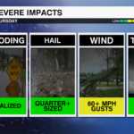
Damaging wind and heavy rain are our primary threats
Severe
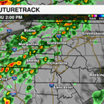
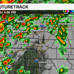
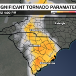
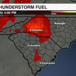
An upper level low moving over the Tennessee Valley will progress north toward the Great Lakes this afternoon. This disturbance is the driving force behind today’s potential severe threat for the region. Showers this morning remained light under overcast skies. The key to what we see later today is literally in the clouds. High shear, decent moisture and lift from the cold front will trigger some afternoon storms. However, we’re lacking instability. If the clouds break, then we will see and increase in instability and the threat of damaging wind and a few tornadoes will increase. As of now, any areas where the clouds were breaking are filling back in.

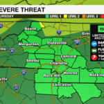
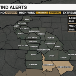
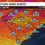
Still the Storm Prediction Center has the region under a marginal risk of severe weather today. The biggest concerns if the clouds hold will be for damaging wind gusts localized flooding. Once the front clears, rain will taper off overnight. Winds will remain strong through Friday with gusts 30-40 mph possible across the Piedmont and 40-50 mph across the mountains due to the strong pressure gradient of the low pressure system moving toward the Great Lakes. This could lead to fallen trees and power outages. Winds will quiet Friday evening into early Saturday with a pleasant and warm forecast for the rest of your weekend.

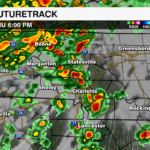
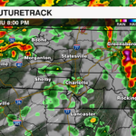
WHAT: Isolated to widely scattered severe storms
WHERE: Across the region severe weather is possible, but east of the Blue Ridge is where some of the strongest storms might set up
THREATS: Damaging Wind Gusts, Localized Flooding. IF instability increases a few tornadoes could be a concern.
TIMING: 4-8pm Thursday

It is important to stay WeatherWise. The WCCB Weather Team will bring you the latest updates with the severe threat. Make sure you download the WCCB WeatherWise App for the latest updates even on the go.


