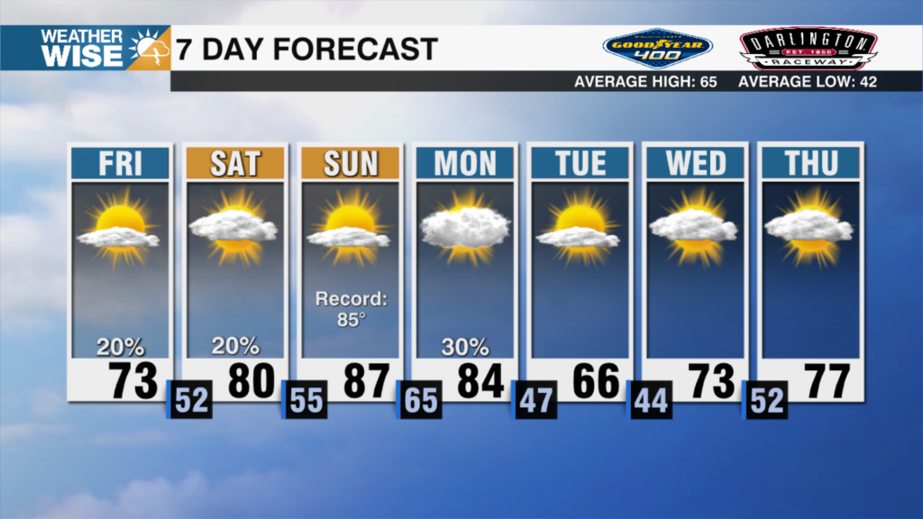
Hot, Humid And Stormy Week
AM Headlines:
- Beryl is the 1st U.S. landfalling hurricane of the season
- Hot and Humid Week
- Afternoon Storms, Chance Heavy Rain
Discussion:
Starting off the day with patchy fog and low clouds, thanks to the rain yesterday. In fact, that was the most rain Charlotte has had since May 15 with rainfall totals of 1.35″ out at the Charlotte Douglas Airport. More afternoon showers and storms possible today, with the risk of some storms capable of producing heavy downpours leading to flash flooding. The remnants of Beryl will begin to influence our weather Tuesday into Wednesday. Although Beryl will travel well west of the region, we’ll feel the influx of moisture from the Gulf making it feel swampy with heat indices in the triple digits. More widespread showers and storms expected during the afternoon, with the localized flooding threat continuing. We’ll need to watch late week for a possible disturbance along the coast. This could bring more widespread rain and storms to the region this weekend if it pulls together. Otherwise, expect a more typical mid-July forecast with temps in the low 90s and pop up afternoon storms.
Hurricane Beryl:
Beryl made landfall near Matagorda, TX around 5am EST Monday. A sustained wind of 68 mph with a gust of 86 mph was picked up at the Matagorda City weather station. It is bringing not only dangerous wind, but life threatening storm surge up to 7 feet with 5-10 inches of rainfall expected and up to 15 inches possible. Beryl will weaken significantly as it moves quickly inland through Texas and the Mississippi Valley over the next 24 hours.