Heat Advisories In Effect Tuesday
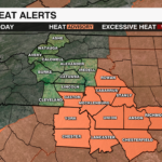
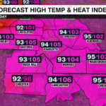
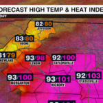


Dangerous heat will spread across the Carolinas today with heat index values climbing above 105. All counties south of I-85 within the WCCB viewing area will be under a heat advisory Tuesday. This includes Anson, Cabarrus, Gaston, Mecklenburg, Richmond, Rowan and Stanly Co., N.C. and Chester, Chesterfield, Lancaster, York Co., S.C. until 8p.m.

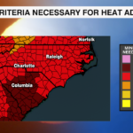
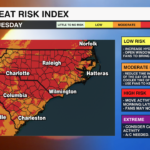
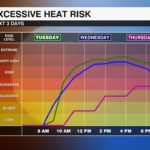
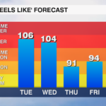
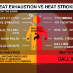
A dome of high pressure is trapping heat and humidity across the region. The combination of high temperatures and elevated humidity levels will make it feel like 105 to up to 109 degrees this afternoon. These conditions are extremely dangerous for those spending extended periods of time outside. Temperatures will not fall below 75 for many locations this evening. Prolonged exposure to high temperatures, even at night, increases the risk of heat related illnesses.
Tips to Stay Safe:
Stay Hydrated: Drink plenty of water even if you don’t feel thirsty. Avoid caffeine and alcoholic beverages.
Limit Outdoor Activities: If possible, try to move outdoor activities early in the morning when temperatures are coolest. If working outside, take plenty of breaks in air conditioning.
Dress Appropriately: Wear loose fitting, lightweight, light colored clothing to help keep cool.
Check On Vulnerable Groups: Keep an eye on children, the elderly and pets as they are most susceptible to heat related illnesses.
Rain and storm chances will remain minimal outside of the higher elevations Tuesday. But, any storms that do develop will have plenty of fuel with the tropical stream of moisture out of the Gulf. An upper level disturbance will drive a cold front across the Carolinas late Wednesday leading to scattered showers and storms. Behind this cold front, drier air will settled into the region Thursday leading to more comfortable humidity levels.
Stay WeatherWise and on top of the latest weather information with the WCCB WeatherWise team by downloading the WCCB Weather App.


