Ernesto Strengthens Back Into A Hurricane
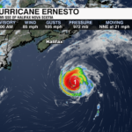
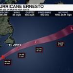
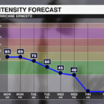
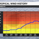
Ernesto made landfall Saturday morning over Bermuda. It weakened into a tropical storm as it moved over the island, but has since strengthened back into a category 1 hurricane. It will remain a hurricane through tonight and it will pass near Newfoundland tonight or early Tuesday with the strongest winds remaining offshore.

The storm will become post tropical by Tuesday as it moves into the cooler waters of the North Atlantic and battles some stronger shear. It will curve back toward the UK by the middle to end of the week, likely merging with a larger extratropical low near Iceland.

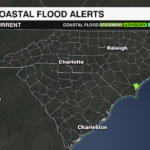
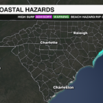
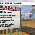
Dangerous surf and rip currents along the U.S. East Coast, Bahamas, Bermuda and Atlantic Canada will remain through the start of the week. Southeastern Newfoundland could experience some coastal flooding due to large waves.
PREVIOUS UPDATE 8/16 5AM
Hurricane Ernesto is currently a category 2 hurricane with sustained winds of 100 mph. Although some strengthening is possible today, increasing wind shear and dry air may limit its intensity. Ernesto will remain a strong and dangerous hurricane as it nears Bermuda with tropical storm conditions beginning for the island later today. The storm will pass near if not over Bermuda Saturday before picking up speed and heading northeast toward Atlantic Canada. It will remain a hurricane through the weekend before weakening and transitioning into a post tropical system early next week.

Ernesto will bring significant threats to Bermuda this weekend with dangerous storm surge, strong wind and flooding rain. It is also producing dangerous swells that will impact the U.S. East Coast this weekend with life threatening surf and rip currents.

HAZARDS:
Wind: Tropical Storm force wind for Bermuda begins today with hurricane conditions through Saturday
Storm Surge: Dangerous storm surge will cause coastal flooding for Bermuda
Rainfall: 6-12″ with isolated areas up to 15″ for Bermuda
Surf: Dangerous swells generated by Ernesto will cause life threatening surf and rip currents for the U.S. East Coast through this weekend
PREVIOUS UPDATE 8/16 8AM
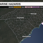
Hurricane warnings are in effect for Bermuda with hurricane conditions likely to begin Friday evening or early Saturday ahead of Hurricane Ernesto. As of the 8am update from the National Hurricane Center, Hurricane Ernesto has strengthened overnight with sustained winds of 85 mph and a central pressure down to 975 mb. Ernesto has turned northward and will turn more toward the northeast over the next day toward Bermuda.

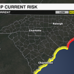
Ernesto is battling some dry air, but it will likely intensify into a major hurricane by Friday evening as it moves over the very warm and open waters of the Atlantic. Although Ernesto will stay far from the U.S. East coast it will produce large swells that will bring life threatening surf and rip currents to the Carolina coast beginning tonight through the weekend. Rip current risks are low Thursday, but will become high by Friday.

Hazards
Wind: Tropical Storm conditions will begin Friday afternoon for Bermuda, with Hurricane conditions beginning Friday night or early Saturday
Rainfall: 4-8″, with isolated amounts up to 12″ for Bermuda. This will lead to life threatening flash flooding.
Surf: Dangerous swells will impact the U.S. East coast beginning tonight through the weekend. This will lead to dangerous surf and life threatening rip currents
PREVIOUS UPDATE 8/15 11PM
After slamming into the British Virgin Islands and bringing heavy rain and strong wind to Puerto Rico, Hurricane Ernesto is now heading toward Bermuda. As of the 11 PM update from the National Hurricane Center, hurricane Ernesto has maximum sustained winds of 80 mph.

Hurricane Warnings are in effect for Bermuda as the storm is expected to pass close by Friday or Saturday.

For the Carolina coasts, expect an increase rip current risk along with rough surf and high seas through the weekend.
PREVIOUS UPDATE 11AM 8/14
Ernesto is now a category 1 hurricane with 75 mph sustained winds based on data collected from the hurricane hunters Wednesday morning. It is moving to the northwest, but is expected to turn north-northwest and then northward later today due to a break in the subtropical ridge and a trough off the U.S. east coast. It is forecast to reach Bermuda by Friday or Saturday. Another trough off the east coast could accelerate Ernesto’s motion toward Canada early next week.

Hurricane Ernesto will strengthen as it moves over the warm open waters of the Atlantic toward Bermuda. It will likely encounter some drier air and increased shear, but should gradually strengthen into a major category 3 hurricane by the end of the week. Tropical Storm Warnings are in effect for the U.S. and British Virgin Islands, Puerto Rico, Vieques and Culebra. A Hurricane Watch will likely be issued for Bermuda later today.

Although Ernesto will stay away from the U.S. East Coast, it will likely produce dangerous swells leading to life threatening rip currents by the end of the week.
Hazards
Rainfall: Flooding rain will continue to fall across Puerto Rico today with 4-10″ total possible. Rainfall will begin affecting Bermuda by Thursday.
Winds: Tropical Storm conditions will continue for Puerto Rico and the Virgin Islands through Wednesday.
Surf: Dangerous swells are affecting the Caribbean and will reach the U.S. East coast by Thursday night, causing life threatening rip currents.
PREVIOUS UPDATE 11AM 8/14
The 11pm update from the National Hurricane Center shows Tropical Storm Ernesto is close to becoming a hurricane. Hurricane Warnings are in effect for U.S. Virgin Islands, British Virgin Islands and Vieques and Culebra.

Heavy rain could lead to flooding in Puerto Rico through Wednesday before Ernesto makes a run toward Bermuda as a powerful major hurricane.

For the Carolina coasts, expect an increase rip current risk along with rough surf mid week through the weekend.
PREVIOUS UPDATE 11 AM 8/12
As of the 11am update from the National Hurricane Center, Tropical Storm Ernesto continues to strengthen as it moves through the Caribbean. It will likely become a hurricane within the next 24 – 36 hours. Hurricane Watches are now in effect for the U.S. and British Virgin Islands, Vieques and Culebra.

It is located 155 miles ESE of St. Croix, or 250 ESE of San Juan Puerto Rico and is moving west-northwest at 18 mph. Current winds are 50 mph with higher gusts and it is forecast to become a hurricane by early Wednesday.
Tropical Storm Warnings remain in effect for several Leeward Islands, as well as Puerto Rico.
It will take a sharp turn to the north beginning tonight and move near Bermuda by this weekend.
Impacts
Rainfall: 4-6″ expected over the Northern Leeward and Virgin Islands. Puerto Rico could see 6-8″, with isolated areas up to 10″ of rain.
Storm Surge: 1-3′ for the east coast of Puerto Rico and the U.S. and British Virgin Islands
Surf: Dangerous surf and rip currents are likely for the Caribbean, Bahamas and Bermuda later this week.
PREVIOUS UPDATE 8/12
Tropical Storm Ernesto has formed. Thankfully for us, it will miss the east coast of the United States.

Ernesto is forecast to move across portions of the Leeward Islands before moving near or over the U.S. and British Virgin Islands and Puerto Rico. Heavy rain and tropical storm force winds will move across the islands Tuesday into Thursday.

Tropical Storm Warnings are in effect for St. Kitts, Nevis, Montserrat, Antigua, Barbuda, and Anguilla, Guadeloupe, St. Martin and St. Barthelemy, British Virgin Island, U.S. Virgin Islands, Puerto Rico, Vieques and Culebra.
Thanks to a trough over the eastern seaboard, Ernesto will make a sharp turn to the north north of Puerto Rico on Wednesday. Toward the end of the week, Ernesto will likely become a hurricane and head toward Bermuda.

For the Carolina coasts, expect an increase rip current risk along with rough surf mid week through the weekend.


