Spook-tacular Halloween Forecast
AM Headlines:
- Warm & Dry Halloween
- Isolated Showers w/ Weak Cold Front
- Weekend Wedge
- Warming Up Next Week
- Finally Better Rain Chances MidWeek
Discussion:
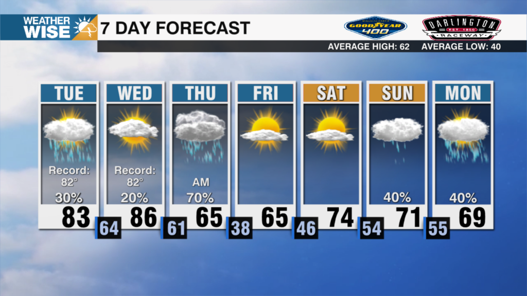
That ridge will keep things dry for all the trick or treaters tonight but this morning we’re kicking off the day with some patchy dense fog across the region. That will clear giving way to a mix of sun and clouds today as highs reach the upper 70s to lower 80s. Temps will remain mild fro the trick or treaters — upper 60s to mid 70s after sunset through the early evening. A weak cold front will approach the area tonight with just isolated showers possible across the mountains and foothills Friday. Clouds will thicken up across the region with temperatures still topping out in the upper 70s Friday afternoon. A weak wedge will set up this weekend locking in the clouds and leading to some spotty sprinkles and drizzle for the region. Highs will remain above average — topping out in the lower 70s through Monday of next week. Temperatures will warm back up by Election Day with highs near 80 Tuesday afternoon. Our best chance of rain since September is possible with a disturbance mid-week.