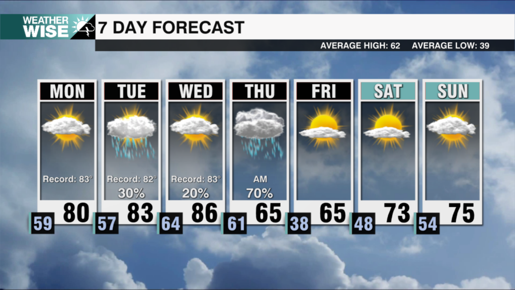
Windy and warmer Wednesday
AM Headlines
- Windy and Warmer Wednesday
- Increased Fire Danger
- Soaking Rain Friday
- Dry and Cooler Weekend
Key Impacts Today
- Wind Advisory (Mountains & Foothills)
- Winds: NW 15-30 Gusts 50-55 mph
- Scattered power outages, downed tree limbs and make travel difficult
- Increased Fire Danger (Piedmont & Foothills)
- NW Gusts 25-35 mph
- Low Relative Humidity Levels – 20-30%
- Outdoor burning is highly discouraged. Any spark could lead to fires quickly spreading
Discussion
Windy & Warmer w/ Increased Fire Danger
A strong low pressure system over the Great Lakes is creating a tightening pressure gradient as high pressure sits over the south. This will drive strong northwest gusts 50+ mph across the high country and foothills today with gusts winds 25-35 mph possible for the Piedmont. Gusty winds with dropping relative humidity levels down to 20-30% will quickly dry out vegetation and lead to an increased fire danger. Outdoor burning is highly discouraged today. Highs will climb into the mid 60s with winds dying down later this evening as the low moves out.
Soaking Rain Friday
Thursday will be more calm with temperatures reaching the low 60s as clouds build in ahead of a warm front. A cut off low over the Plains will strengthen as it moves east pulling in deep Gulf moisture into the Carolinas Friday. Light scattered showers will become more steady with a good soaking rain in the forecast Friday afternoon. Rainfall totals will be highest fo the mountains and foothills with .5-1″ of rainfall likely for the area. Instability still remains low, but some gusty winds could be possible later in the day.
Drier and Cooler Weekend
Rain clears by Saturday morning as the system moves off the coast. Winds will transition out of the northwest ushering in drier and cooler air with highs still reaching the low 60s Saturday afternoon. A weak wedge will build in Sunday leading to a drop in temps with highs back in the 50s. Zonal flow will lead to another warm up into the mid to upper 60s early next week.