Isolated severe threat Thursday
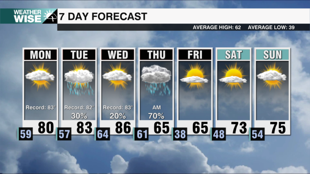
AM Headlines
- Warming Up
- Scattered Showers and Storms
- Isolated Severe Threat
- Unsettled, Staying Warm this Weekend
- Messy and Colder Next Week
Severe Threat TODAY Level 1 (out of 5)
There is a low end severe threat today, generally north of I-40. Storms will develop throughout the day along a stalled front west of the area. Severe threat increases late this afternoon with storms developing along the front and coming out of TN. Storms will likely weaken the further east they track, but we’ll need to keep an eye on any storm that holds together into the Foothills and Northern Piedmont.
Where: Mountains/Foothills
When: 4pm – 10pm
Threats: Damaging wind, hail, very low tornado threat
Discussion
A stalled boundary, northwest of the area will drive a few rounds of showers and storms into the region today. Isolated strong to severe storms capable of producing damaging wind and hail possible for the mountains and foothills late this afternoon into the evening. The wedge will erode today leading to warmer temperatures with highs reaching the mid 60s to near 70 this afternoon. Friday will begin quiet with temperatures warming back into the 70s, before more scattered showers arrive later in the day through Saturday. The weekend will be unsettled with highs warming from the mid 60s Saturday to the low to mid 70s Sunday ahead of a stronger cold front. That front will likely stall making for a messy and colder outlook next week. Highs will fall back into the 40s with lows falling into the 30s and the potential for a wintry mix across parts of the high country.