Cold and messy week
AM Headlines:
- Winter Storm Warning for Ashe County
- Wedge of Cold Air
- Rain Returns Tonight
- Cold, Soaking Rain through Midweek
- Wintry Mix for Mountains, Foothills
- Late Week Warm Up, More Storms
Discussion:
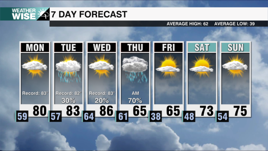
A strong wedge of cold air has settled into the Carolinas, keeping temperatures much cooler than the record highs we saw over the weekend. Cloudy skies will keep temperatures in the low to mid 50s today with the first of several waves of wet and potentially wintry weather moving in tonight. Most of the region will only see a cold rain, but freezing rain will be possible for the northern foothills and high country. Impacts could include slick roads and light ice accumulation to trees and power lines. A winter storm warning will go into effect for Ashe County Tuesday 6am through noon Wednesday, with winter weather advisories likely to follow for the rest of the high country and northern foothills.
Tuesday and Wednesday will be a washout, with multiple rounds of rain. Rainfall totals could exceed 2-4 inches in some spots, leading to localized flooding concerns, especially in poor drainage areas and along creeks and streams. If the cold air holds, some freezing rain could mix in again Tuesday night into early Wednesday as temperatures fall from the low 40s during the day to low to mid 30s overnight.
By Thursday the wedge will begin to break down as high pressure moves off the coast of New England, allowing temperatures to climb into the mid 60s as a warm front lifts across the area. But, a strong storm system could bring another round of heavy rain and storms, sending high temps back in the low 50s Friday.
Another round of strong storms will arrives this weekend, bringing more heavy rain and possibly strong storms Saturday and Sunday. Given the already saturated ground, flooding will be a concern and need to be monitored.