Winter Storm Warning issued for parts of the High Country
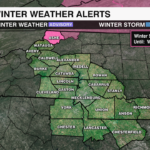
A Winter Storm Warning will go into effect for Ashe County 4 a.m. Tuesday through 4 p.m. Wednesday bringing the threat of significant ice and dangerous travel conditions. This winter storm is enhanced by a classic cold air damming set up, where colder air gets trapped east of the Appalachians, while warmer, moisture rich air overrides it creating a transition zone for snow, sleet and freezing rain.

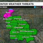
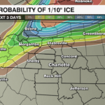
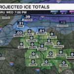
The depth of the cold air wedge determines what type of precipitation we will see. Shallow cold air will likely lead to some re-freezing at or near the surface for the high country and foothills. While the column of air will likely remain above freezing for the Piedmont leading to a cold rain.

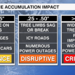
Ice accumulations of .25-.50″ will be possible for the high country with a light glaze into the I-40 stretch. Any ice accumulation can make travel dangerous, but ice accumulation more than .25″ can snap tree branches and cause isolated power outages. More than .50″ of ice can bring down power lines and vcause widespread, multi day outages. 
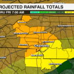
The rest of the area may see some sleet early Tuesday, but this will transition quickly to a straight cold rain with 1-2″ of rainfall likely through Thursday.
The cold wedge will erode Thursday leading to a brief warm up into the 50s and 60s, before more rain arrives for the weekend.
Stay WeatherWise and download the WCCB Weather App for the latest on impacts from this winter storm.


