Waves of cold rain and mountain ice continue through Thursday
Scattered power outages are possible in the mountains as ice weighs down trees and power lines.
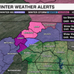

NEW: The Winter Weather Advisories have been canceled in the Foothills and the northern Piedmont. This is going to be a mountain event – this includes eastern facing slopes in Burke and Caldwell counties.
Winter Storm Warnings continue for Ashe and Watauga counties.
- Timing: Until 4 pm Wednesday.
- Snow/sleet totals: 2-5”
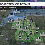
- Ice totals: 0.10”-0.40”
- Impacts: Scattered power outages along with downed trees are possible. Roads will be treacherous and in some cases, impassable.
Ice Storm Warning in effect for Avery county and the eastern facing slopes of Burke county.
- Timing: Until 7 AM Wednesday.
- Ice totals: Ice accumulations around 0.50”
- Impacts: Some roads will likely be impassable. Scattered power outages are possible as ice weighs down trees and power lines.

Rain Threat:
- Timing:
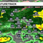
- Wave 1: Widespread rain continues through Wednesday morning
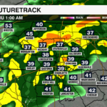
- Wave 2: Wednesday afternoon through the evening
- Wave 3: This weekend
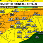
- Totals: 1-2” through Thursday, but 2-4” through the weekend
- Impacts: Nuisance flooding is possible in low-lying areas.

SEE TOP FOR LATEST UPDATE
Winter Storm Warning in effect for Ashe county from 4 AM Tuesday to 4 PM Wednesday.
Winter Weather Advisory in effect for part of the mountains, foothills and northern piedmont from 1 AM Tuesday to 7 AM Wednesday
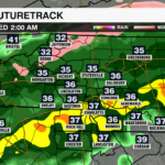
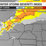
Waves of rain and ice will impact the Carolinas through the middle of the week. The mountains will see ice accumulation, while the piedmont will see a cold rain.
ICE THREAT:
TIMING: A wintry mix will move in overnight into Tuesday morning across parts of the mountains and northern Foothills.
WHAT: A wintry mix then freezing rain.
- Ashe County: Up to 0.50” of ice.
- Mountains: 0.25” of ice .
- Northern Piedmont: Few hundredths of an inch of ice possible.

IMPACTS: The ice will likely be a non-issue for the northern piedmont, but in the mountains – ice accumulation on power lines could cause power outages. Bridges and overpasses will be slick.
RAIN THREAT:
TIMING:
- Wave 1: Numerous to widespread rain will increase Tuesday afternoon and continue through early Wednesday.
- Wave 2: Wednesday afternoon through the evening
- Wave 3: This weekend
TOTALS:
- Mountains: 2-3”
- Foothills: 1.5-3”
- Piedmont: 1-3′
IMPACTS: Nuisance flooding is possible in low-lying areas. IF rain totals increase, there will likely be a Flood Watch, but for now, one is not in effect.