Winter Weather Advisory upgraded to Ice Storm Warning for parts of the region
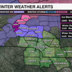
An Ice Storm Warning is now in effect for Avery County and the Burke County Mountains until 7 a.m. Wednesday, due to the potential of accelerated ice accumulation this afternoon and evening. Ice accumulations of .25″ to .50″ will be possible across the high country with a Winter Storm Warning in effect for Ashe and Watuaga counties until 4 p.m. Wednesday. While a Winter Weather Advisory remains in effect for locations across the foothills where a light glaze of ice will be possible for the following counties, Burke, Caldwell, Alexander, Catawba and Iredell Counties until 7 a.m. Wednesday.

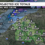
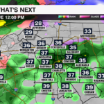
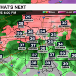
A wintry mix in the mountains will transition to freezing rain by midday as a warm nose edges into the region. Surface temperatures will fall near freezing within the Foothills tonight leading to the change from a cold to freezing rain later this evening. Precipitaiton rates will increase due to stronger moisture transport out of the Gulf due to a strengthening low level jet, enhanced atmospheric lift due to the strong temperature contrast between the cold air trapped at the surface and warmer air aloft, and stronger forcing of rain due to frontogenesis and orographic lift over the mountains. Increased freezing rain rates = higher ice accumulation.

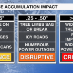
Ice accumulation more than .25″ could lead to not only disruptive travel, but also bring down tree limbs and cause scattered power outages due to the weight of the ice. Ice accumulation more than .50″ could cause widespread power outages and impassable travel.
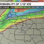
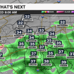
By Wednesday morning, the low level jet will shift east and high pressure over the northeast will shift further away from the New England coast. This will bring an end to the freezing rain across the higher elevations and shift the heavier rain further east. Temperatures will also begin to rise as the wedge begins to erode allowing temperatures to rise above freezing by Wednesday afternoon.


