Sunny skies, warmer highs continue
Rain chances return by Thursday evening, but the sunshine sticks around for the next several days.
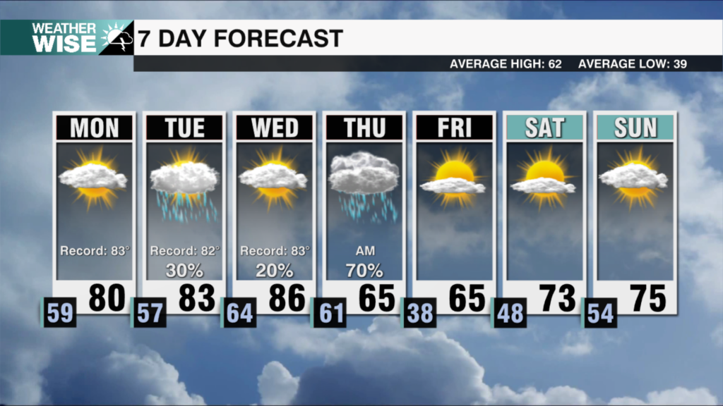
The final weekend of February has been among the month’s best – and the good times continue their roll into the workweek. The sunshine continues its dominance over the Carolina skies on Monday as highs swell into the 50s and 60s across the board. Southwesterly winds pick up on Tuesday, bringing us the warmest air we’ve seen in what will be over two weeks. Highs should reach 70º around the Metro for the second day of the workweek while the mountains enjoy an afternoon closer to 60º. The mercury takes another step higher on Wednesday, but a pattern change arrives as a cold front approaches from the northwest.
Rain chances on Thursday have been trending upward, but it still doesn’t look like a major event. Scattered showers and even a stray thunderstorm or two roll into the WCCB Charlotte viewing area by the evening. The incoming system will sharply cool temperatures – lows dip back near freezing as we wake up Friday morning – but the cold snap won’t last long. Highs should return to above-normal values by the end of the weekend. Medium-range models are picking up on another possible disturbance next Sunday, but next weekend looks largely dry right now.
Tonight: Variable clouds. Chilly. Low: 34°. Wind: Light.
Monday: Comfy sunshine. High: 63°. Wind: S 5-10.
Monday Night: Another chilly night. Low: 36°. Wind: Light.
Tuesday: Beautiful. High: 70°. SW 5-10.