WeatherWise Alert: heavy rain and low end severe risk Monday
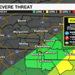
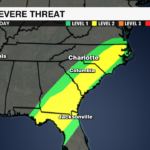


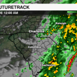

A soggy and unsettled Monday is underway across the region as a cold front slowly pushes through the Carolinas. Rain will be widespread through early afternoon, with the potential for a few gusty thunderstorms, especially south and east of I-85. While widespread severe weather is not expected, a few storms could briefly turn strong to severe with the Storm Prediction Center highlighting a level 2 (out of 5) severe threat for the far southeastern zones of the region from midday through the early evening.

Main Threats
- Damaging Wind Gusts
- Isolated, Brief Tornado
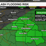
- Localized Flooding
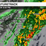
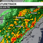
A deep upper level trough is swinging through the Southeast today, providing the lift needed to squeeze out moisture already in place. A cold front associated with the upper level disturbance will move through the region today, acting as a trigger to provide lift for rain and a few storms.

Ahead of the front, we’ve got warm, muggy air in place with dew points in the 60s and just enough energy for storms south and east of I-85 to support isolated to scattered thunderstorms. The low level jet will also be strong enough to give any stronger storms the chance to briefly rotate or produce damaging wind gusts.

Rain will be steady for much of the morning, with a few downpours developing through midday. Most of the region is on track to pick up 1-2 inches of rainfall, but locally higher totals are possible where storms track repeatedly over the same areas.

Urban, low-lying and/or poor drainage areas will be most vulnerable to nuisance flooding. The threat will peak during the evening commute, before rain starts to clear tonight.

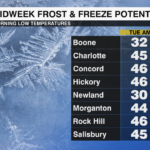
Behind the cold front, temperatures will fall quickly and by Tuesday night, there will likely be frost and freeze alerts issued for the region as lows plummet into the 20s and 30s.
Download the WCCB Weather App to track today’s wet weather and stay on top of any potential storms with updates from the WeatherWise team.


