Summer-like heat ahead
Rain chances don't arrive until Tuesday at the earliest.
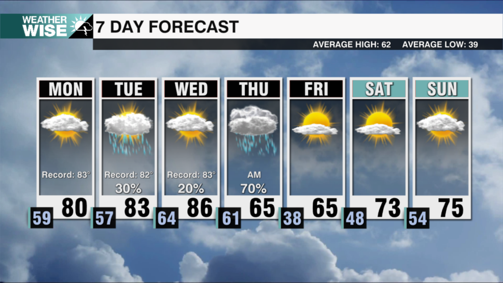
It’s about to get spicy. Southwesterly winds return by Friday afternoon as a strong ridge of high pressure sets up to our east. Highs will soar into the lower 80s across the Piedmont and Foothills to close out the workweek, while the High Country enjoys the mid-to-lower 70s. The blowtorch continues into the weekend as wind gusts approach 25 mph; highs will take another step deeper into the 80s on Saturday. The Queen City hasn’t cracked 90° yet in 2025, but we’ll come close this weekend.
The Carolinas have largely dried up after a wet start to the month. Rain chances won’t arrive until Tuesday at the earliest as a weak cold front pushes toward our area from the northwest. Medium-range models are suggesting the incoming system will stall over the Carolinas by midweek, which will lead to isolated-to-scattered afternoon thunderstorms. Humidity levels will steadily rise as well, giving us a more summer-like feel over the next seven days.
Tonight: Cloudy with a few showers. Low: 52°. Wind: SE 5-10.
Friday: Overcast with scattered showers and storms. High: 83°. Wind: SW 5-15. Gusts: 20+
Friday Night: Mostly cloudy early, then clearing late. Low: 60°. Wind: SW 5-15.
Saturday: AM few clouds. PM mostly sunny. High: 88°. Wind: SW 5-15. Gusts: 20+