Comfy Sunday, summerlike heat lurks ahead
Rain chances largely remain at bay through the remainder of the month.
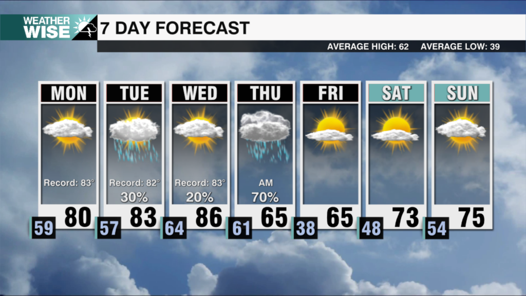
April’s final weekend is off to a hot and humid start, but some sweet relief is just around the corner as a cold front sweeps through the Carolinas. Lows will fall into the 40s and 50s across the board Sunday morning after topping out in the 70s and 80s Saturday afternoon. Despite abundant sunshine, highs only rise into the mid-to-lower 70s around the Metro to close out the weekend while the mountains hang in the 60s.
The cooler air won’t last long. Aided by bright skies and southerly winds, afternoon temperatures will quickly rise into the upper 70s on Monday. The return of the 80s soon follows on Tuesday before highs soar near 90º across the Piedmont and Foothills for the April’s Wednesday finale. Medium-range models are trending wetter towards the back half of the week as we kick off May, but rain chances slump near 0% through Tuesday.
Tonight: A stray storm early, then mostly clear. Much cooler. Low: 56°. Wind: NE 5-15.
Sunday: Sunny and comfy. High: 74°. Wind: NE 5-15.
Sunday Night: Another nice night. Low: 53°. Wind: Light.
Monday: Mostly sunny. Warmer. High: 78°. SE 5-10.