Summerlike pattern continues
Rain chances remain in the isolated range before surging ahead of Saturday's cold front.
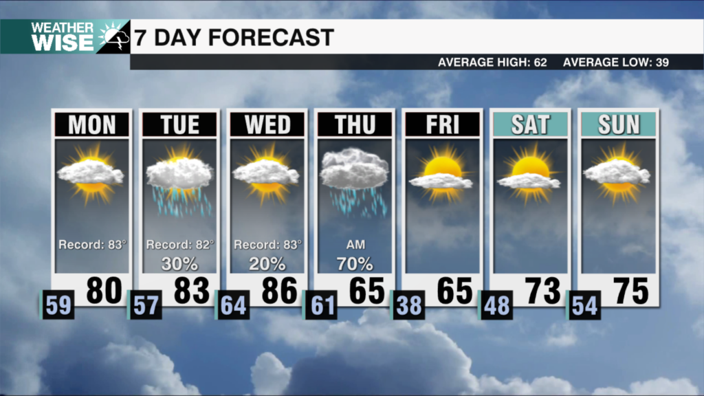
Summer has found its way back into the Carolinas this Wednesday afternoon as highs soar well into the 80s across the Piedmont and Foothills. A few storms have popped up along and north of I-40, but they should stay well away from the Metro overnight as lows only dip into the 50s and 60s across the board. Afternoon temperatures will pick up where they left off on our first day of May on Thursday, returning to the mid-80s with only a few isolated afternoon storms left to cool us down. While we’ll still see more sunshine and blue sky than anything else on Friday, clouds will steadily build as isolated pop-up storms roll in later in the day ahead of a rainmaking system that arrives by the weekend.
A strong cold front approaches from the northwest Saturday afternoon, sharply bumping up rain chances for May’s first weekend. While it won’t be a washout, we’ll need to watch for scattered heavy, gusty storms through Saturday evening. A few lingering showers may carry into the early morning hours Sunday, but we’ll be all clear by noon. Noticeably cooler and drier air filters in from the northwest to close out the weekend – highs will fall from near 80° on Saturday to the mid-to-lower 70s across the Piedmont and Foohtills on Sunday.
Tonight: Variable clouds. Low: 65º. Wind: SW 5-10.
Thursday: Mostly sunny with a few PM storms. High: 85°. Wind: SW 5-15. Gusts: 20+
Thursday Night: A stray storm early, then partly cloudy. Low: 65°. Wind: SW 5-15.
Friday: Mostly sunny. PM isolated storms. High: 83°. Wind: S 5-15. Gusts: 20+