Potential for tropical development off Southeast coast diminish, but heavy rain, possible flooding threat remains for Carolinas
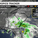
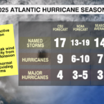
The weak system lifting out of Florida toward the southeast, now has a 0% chance of tropical development as of the 8 a.m. update from the National Hurricane Center. Although this means this system will not be the first named storm of the 2025 Atlantic Hurricane Season, it still brings a heavy rain and potential flooding threat to the Carolinas.

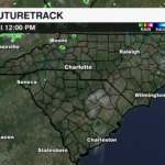
While the National Hurricane Center highlighted an area off the southeast coast where the system could gain tropical characteristics, recent model trends are now more favorable that the broad area of disorganized thunderstorms will develop inland as a non-tropical low over the Carolinas Thursday. This ultimately cuts off the systems ability to tap into the warm ocean waters needed for tropical development.
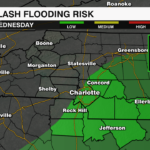
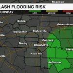
Even though tropical development is no longer a concern, the system is still pulling deep tropical moisture into the southeast that will fuel the disturbance, bringing heavy rain to parts of the southeast as it drifts north through the end of the week. The greatest threat of flash flooding will be for areas closest to the coast where the heaviest rain will likely fall. However, localized flooding from heavy rain bands may cause issues as far inland as the I-85 corridor through Thursday.

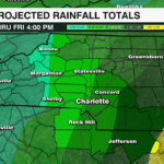
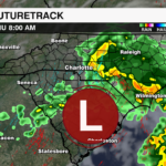
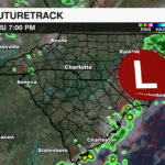
Locally, showers will begin to push into the region tonight, with steady rain for areas near and to the south and east of I-85 overnight. Light showers may push as far west as the high country Thursday morning, but steady rain will be more likely from the Piedmont to the coast. Showers will gradually taper off Thursday evening for the Charlotte Metro area Thursday evening, and end for N.C. coastal communities Friday afternoon as the low moves away from the Carolinas and east into the Atlantic.
Rainfall totals of .25″ to 1″ will be possible for the Charlotte Metro area, with up to 1-2″ of rain for the far eastern fringe of the region. No widespread flooding is expected locally, but isolated pockets of localized flooding will be possible, especially where heavier rain bands set up.
Stay up with the latest on the tropics with the WeatherWise team by downloading the WCCB Weather App.