Summer surges into weekend
We'll want to stay weather-wise for scattered strong storms Saturday afternoon, but the weekend won't be a washout.
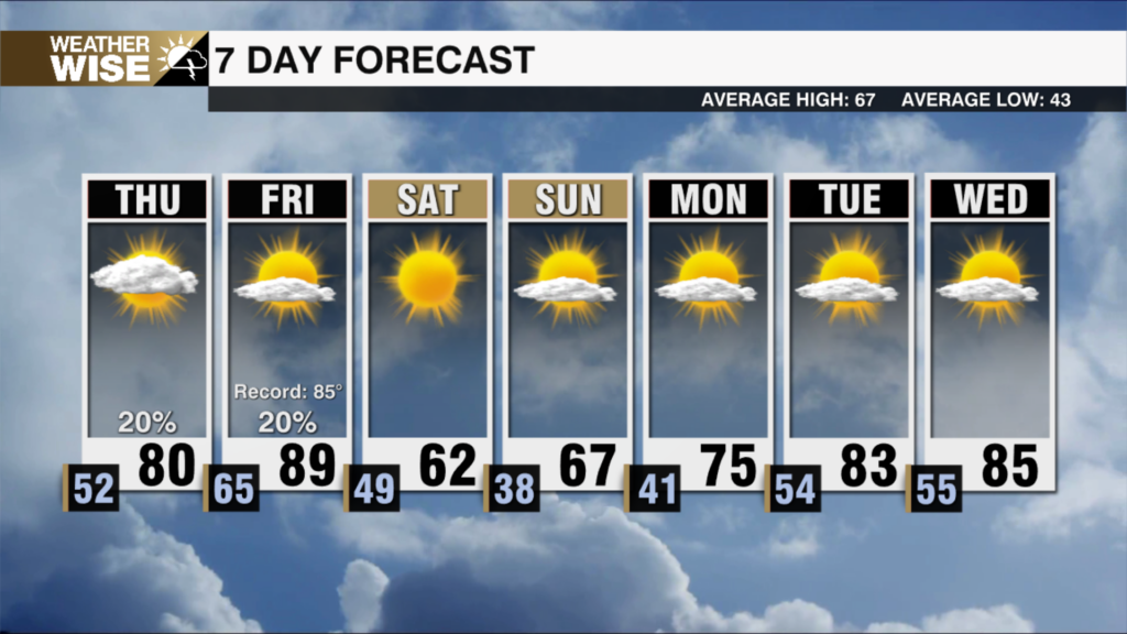
A cloudy and rainy gloom has been cast across much of the WCCB Charlotte viewing area this Thursday as a coastal low slugs through the Carolinas, but big-time changes arrive in time for the weekend. While isolated storm chances linger into Friday, the more notable story for our final day of the workweek will be the heat. Highs will soar near 90° across the Piedmont and Foothills; the Queen City may very well find itself in the 90s for the first time in 2025 on both Friday and Saturday. A Level 1 out of 5 risk has been posted for the western Carolinas on Friday, as a few of these isolated storms may pack gusty winds and small hail.
A Level 2 out of 5 risk currently covers the majority of the WCCB Charlotte viewing area on Saturday. Short-range models are backing off the prospect for widespread severe weather, but we’ll want to watch carefully for any cells that get going in the afternoon. Once again, gusty winds and small hail are the main threats, but there will be some spin available along a cold front as it pushes into the region by Saturday night. The heat, humidity, and afternoon storm chances carry into June’s second workweek – summer is here to stay.
Tonight: Cloudy. Mild and muggy. Low: 66°. Wind: Light.
Friday: Hot and humid. Stray PM storm? High: 90°. Wind: SW 5-10
Friday Night: A stray storm early, then variable clouds. Low: 71°. Wind: SW 5-10.
Saturday: Another hot one. PM scattered storms. High: 90°. Wind: SW 5-15.