Summer not done yet
Fire danger may increase over the next week as rain chances remain few and far between.
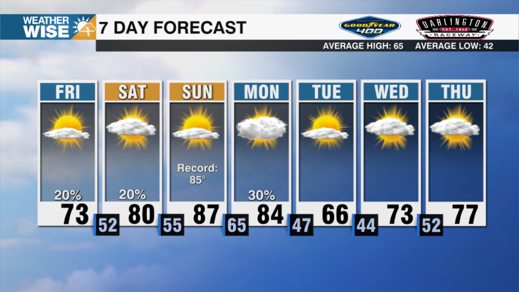
Happy Hump Day! After a cloudy start, sunny skies will erupt across the WCCB Charlotte viewing area this Wednesday afternoon as temperatures reach into the mid-80s around the Metro. Expect more of the same on Thursday as temperatures climb into the upper 80s across the Piedmont and Foothills. Summer reminds us she’s not done just yet on Friday and Saturday; Charlotte could crack 90° for the first time in a month as we roll into the season’s final weekend. Temperatures cool by the first day of fall on Monday, although most locations will end up near normal in the 70s and 80s across the board. Rain chances appear few and far between over the next five days.
It’s looking like a given that we’ll see Tropical Storm Gabrielle form well east of the Caribbean over the next 24 hours. Models continue to take future Gabrielle away from the U.S. mainland, but Bermuda could be in for a rough time next week. There are no immediate tropical threats to the Carolinas over the next 7-10 days, but it’s important to stay weather-wise as we march through the peak of hurricane season.
Today: AM variable clouds. PM sunshine. High: 84°. Wind: NW 5-10.
Tonight: Clear and comfy. Low: 64°. Wind: Light.
Thursday: Another nice day. Even warmer. High: 87°. Wind: Light.
Thursday Night: Mostly clear. Low: 64°. Wind: Light.
Friday: Sunny skies. Toasty highs. High: 90°. Wind: N 5-10.