Summer heat to start the fall equinox
Rain chances on the rise later this week
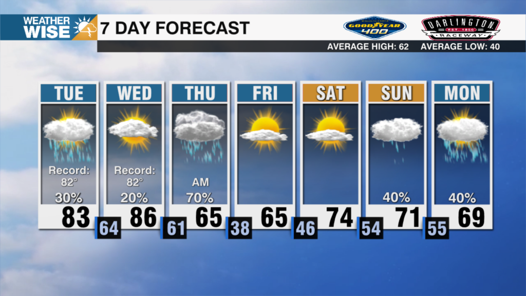
The summer heat and humidity are hanging around for the official start of fall on Monday. Highs on Monday will be in the mid to upper 80s across the Piedmont, with mid 70s in the High Country. The humidity will be manageable, but will be higher than many would like as we hit the fall equinox. The same summer pattern hangs through Wednesday. By Wednesday, humidity will become more summer-like, and temperatures will be in the upper 80s. Rain chances will be next to none across the Piedmont through Tuesday, but a couple afternoon showers and storms are possible in the High Country.
Rain chances hit isolated criteria on Wednesday, as our next weather maker approaches from the west. The brunt of the system arrives Thursday and into Friday with widespread rain chances. The exact timing will need to be ironed out, but rain is likely. We may need to watch for a couple of strong storms with this system, but that will depend on the exact timing of when the main front works through. Most model guidance gets the rain out by Saturday. If that holds, weekend plans look good with seasonable weather.
Tropical Storm Gabrielle looks to become a hurricane over the coming days, but luckily will stay well offshore and curve out to sea. There are two other waves that need to be monitored as they cross the tropical Atlantic this week. One with a low chance of development, and the other with a medium chance. It’s too soon to know where these will end up, but any United States impacts look unlikely at this point. Obviously, things change in a flash in the tropics, so we will keep you up to date right here on WCCB!
Tonight: Partly cloudy. Low: 63°. Wind: E 5
Monday: Partly cloudy. High 87°. Wind: Calm
Monday Night: Partly cloudy. Low: 63°. Wind: Calm
Tuesday: Partly cloudy. High 88°. Wind SW 5