Another cooldown later this week
Our next chance of rain in sight
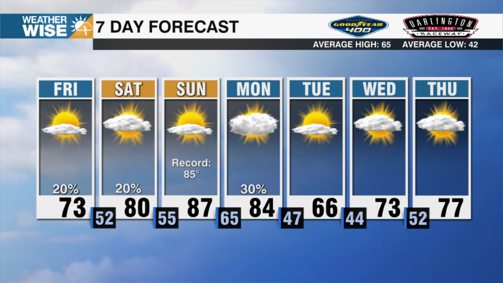
Another beautiful Sunday in the Queen City is wrapping up! If you liked today’s weather, then you’ll be a fan of Monday. Temperatures get to the low 80s in the Piedmont, and low 70s in the High Country. These temperatures are a couple degrees above average for this time of year, so make sure to enjoy the warmer weather. By Tuesday, the thermometer stays steady, but a much more humid feel works in. This humidity peaks on Wednesday as our next chance at rain works in.
I’ll start by saying the chance for rain Wednesday isn’t a slam dunk. The core of the storm system will be well north into Canada. This means our lifting mechanism to get showers and storms going is pretty weak. With that said, I do expect at least a couple of showers or storms to work across the area. If you do see rain, count yourself lucky, as many of us are in a low-grade drought. By Thursday, the front clears and stout flow from the northeast brings beautiful, dry air into the area. This means highs will be stuck in the upper 60s and low 70s Thursday and Friday! So if you planned on visiting the pumpkin patch, those look like the days to do it!
Meanwhile, the tropics aren’t giving up yet with an area with a high chance of developing off the west coast of Africa. The good news is this looks to curve out to sea well before the lower 48. We also need to watch the potential for a storm system to develop off the east coast later this week. This is unlikely to be purely tropical, and right now has a very low chance of impacting our weather in a direct way. Either way, something to monitor this week!
Tonight: Mostly Cloudy. Low: 61°. Wind: E 5
Monday: Partly Cloudy. High 81°. Wind: E 5
Monday Night: Partly Cloudy. Low: 62°. Wind: E 5
Tuesday: Mostly Cloudy. High 82°. Wind SE 5