Beautiful weather brings increased fire danger
Fire danger increasing
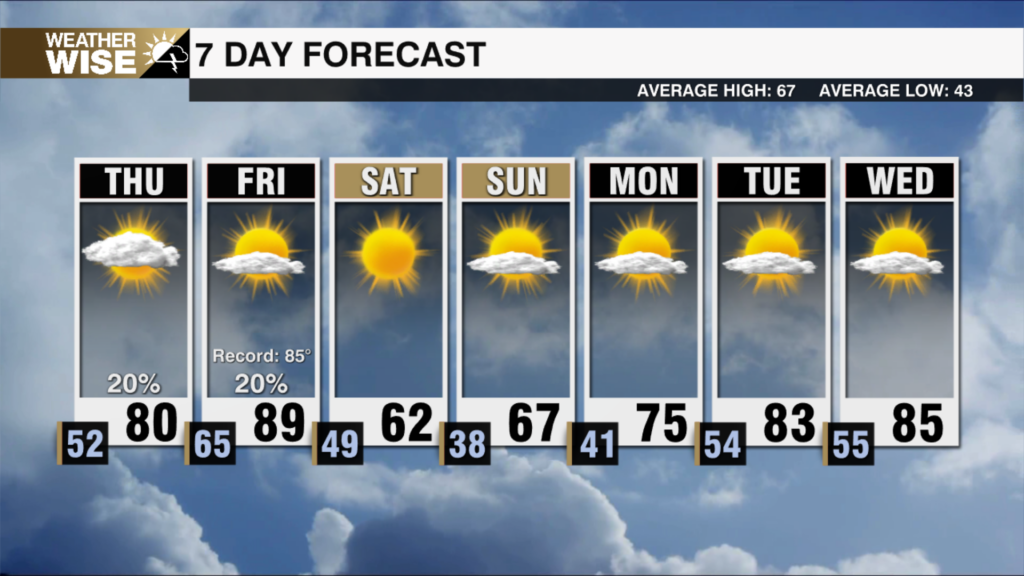
It was a picture-perfect day across the Piedmont to start the weekend. The trend looks to continue for our Sunday. Highs will reach the mid 70s in Charlotte tomorrow and upper 50s in the High Country. We could see a couple AM showers in the High Country, but dry weather dominates Sunday across the area. Those isolated High Country showers are thanks to an approaching cold front. While it won’t bring rain outside of the High Country, it will increase wind and funnel in drier air by Sunday afternoon and evening. This combination will increase fire danger across the entire viewing area. So if you can avoid burning anything, I encourage avoiding it!
The dry conditions continue on Monday, but temperatures significantly drop with highs in the low 60s for the Piedmont. The cooler weather doesn’t last long as the warming trend resumes by Tuesday. A couple weak systems look to cross to our north through the week. So while rain chances aren’t zero, it looks mostly dry, especially in the Piedmont. This means we will likely maintain the elevated fire danger through much of the week.
In terms of rain on the horizon, the next best chance looks to be Friday and Saturday of this coming week. It’s not a slam dunk, but hopefully we can squeeze something out of it to ease drought and fire concerns!
Tonight: Partly cloudy. Low: 57°. Wind: SW 10-15
Sunday: Mostly sunny. High 76°. Wind: NW 5-10
Sunday Night: Mostly clear. Low: 39°. Wind: NW 5-10
Monday: Mostly sunny. High 64°. Wind: Calm