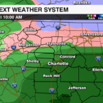
Winter Weather could impact parts of the Carolinas on Friday
A brief period of snow or freezing rain is possible in the piedmont, but accumulating snow will likely stay north of I-40
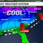

CHARLOTTE, N.C. — With an area of high pressure to our north supplying cold air and a low pressure to our south supplying moisture, there will be a chance for a wintry mix across the WCCB Charlotte area on Friday.
This looks to be an I-40 to the north event and a not a piedmont event, however, a few flakes or a period of wintry mix is not out of the question. For most of the area, prepare for a cold rain.
TIMING: Friday morning and afternoon with a few lingering rain showers to the south and snow showers across the mountains.
IMPACTS: The impacts will be minimal, but those north of I-40 could see slick bridges and overpasses.
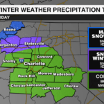
PRECIPITATION TYPE:
Mountains: Snow and wintry mix
Foothills: Snow, wintry mix and cold front
Piedmont: Possibly a brief period of a wintry mix, but mainly all cold rain.