A weather rollercoaster begins
Tracking big temperature swings
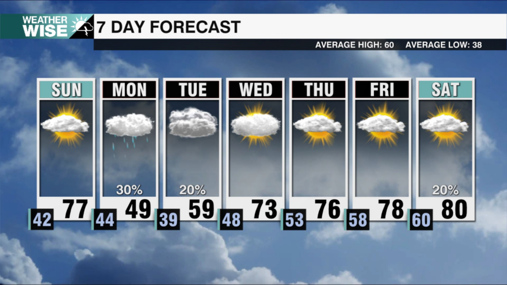
After a record-warm Christmas in the Queen City, we finally came back to reality today. Many have dropped 20 or more degrees today compared to yesterday’s high temperatures. However, this doesn’t look to last long as big swings once more overtake the forecast through the weekend. Tomorrow looks to once again warm up significantly as the cloud cover breaks. I will caution you, setups like the one we are in today can linger longer than models suggest. So while the most likely scenario tomorrow is a return to sun and highs in the low 70s. The clouds and cooler temperatures could hold on longer than currently projected for some. Either way we look to stay dry, and another swing follows on Sunday.
The clouds and cooler air once again look to lock into the area on Sunday as winds shift out of the east. Sunday will feature the chance for a shower or spotty drizzle as well. This once again won’t last long as our next system approaches from the west. This briefly increases flow from the south which helps us to warm up into the 60s early Monday with a few showers possible in the morning. Then cooler and drier air funnels in by Monday afternoon helping to flatten out our roller coaster for a period. Tuesday through Friday looks to be seasonable with slightly below average highs and plenty of sunshine!
Make sure to dress accordingly for the swings ahead, and stick with the WCCB weather team for the latest!
Tonight: Patchy fog. Low: 51°. Wind: Calm
Saturday: Partly cloudy. High 72°. Wind: SW 5-10
Saturday Night: Mostly cloudy. Low: 48°. Wind: Calm
Sunday: Cloudy. High 52°. Wind: E 5