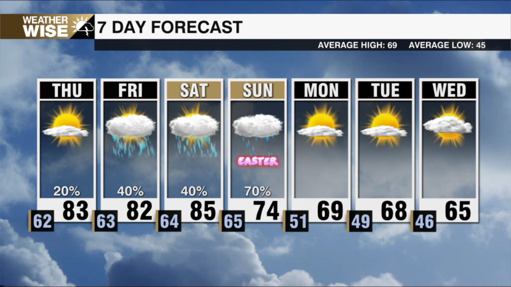
Weekend Winter Storm: Power Outage Risk To Rise Later Today
Tracking the latest winter storm timing
CHARLOTTE, NORTH CAROLINA (WCCB) —
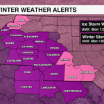
Ice Storm Warning in effect for the piedmont, foothills along with Avery county until Monday at 1 pm.
Winter Storm Warning in effect for Ashe and Watauga counties until Monday at 1 pm.
 Winter Storm Watch is in effect for Stanly, Anson and Richmond counties until Monday at 1 pm. FORECAST TOTAL SNOW/SLEET AND ICE TOTALS TO COME:
- NC Piedmont:
- Ice: 0.25”+
- Sleet: 1-3+”
- Foothills:
- Ice: 0.10-.25″+
- Snow & Sleet: 2-4”
- Mountains:
- Ice: 0.10-.25″+
- Snow & Sleet: 2-4”

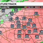
TIMING:
- Light to moderate sleet and freezing rain will continue to be on an off through this afternoon
- After 3:00pm a line of more intense sleet and freezing rain begins to work west to east across the viewing area
- Wind gusts will pick up, and even some thunder is possible
- By 8:00pm many of us dry out as temperatures stay near or below freezing
IMPACTS:
- Widespread hazardous to treacherous road conditions
- Power outages will begin to rise starting this afternoon and continue into the overnight as winds pick up
- Travel will remain very hazardous tomorrow across the region
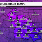
COLD TEMPERATURES:
- Temperatures stay below freezing today meaning anything that falls will stick.
- Tomorrow we warm up to the mid to upper 30s
- Monday night a hard refreeze occurs as we plummet into the teens and single digits
- Black ice will be common every morning this week
- Temperatures stay well below average all week with highs in the 30s and lows in the 20s or colder