Strong Christmas Eve Cold Front
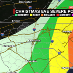
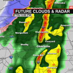
A strong cold front will bring the threat of isolated severe storms on Christmas Eve. The biggest threat for the area will be the potential for these storms to produce damaging wind gusts – especially for areas east of I-77. Heavy rain could lead to localized flooding. The severe weather threat increases the farther east you are in North Carolina.


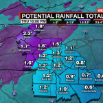
Showers and patchy fog will begin overnight. Showers will become more steady on Christmas Eve morning. Temps will warm to the 60s, but a few areas south and east of Charlotte could even reach the low 70s. This will help spawn a few rumbles of thunder during the afternoon, and a few of these storms could produce damaging wind gusts. Localized flooding could also be a concern with 1-2” of rainfall possible. Colder air will reach the mountains late Thursday. Expect an inch to two for areas below 3500’ and 3-4” for areas above.


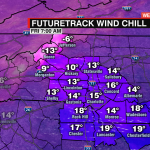
No white Christmas for the Foothills or Piedmont, but temps will be dropping fast Thursday night. That along with strong winds will make it feel like temps are in the teens for the Piedmont and below zero for the mountains. It will remain blustery throughout Christmas Day. Highs will technically reach the upper 30s, but it won’t feel even close to that with the wind. Freezing temps will spill into the weekend, but seasonable highs will return by Sunday.