
Taste of Charlotte Forecast
The Taste of Charlotte kicked off Friday evening. Beautiful, but hot weather, is expected through the weekend.
The Taste of Charlotte kicked off Friday evening. Beautiful, but hot weather, is expected through the weekend.
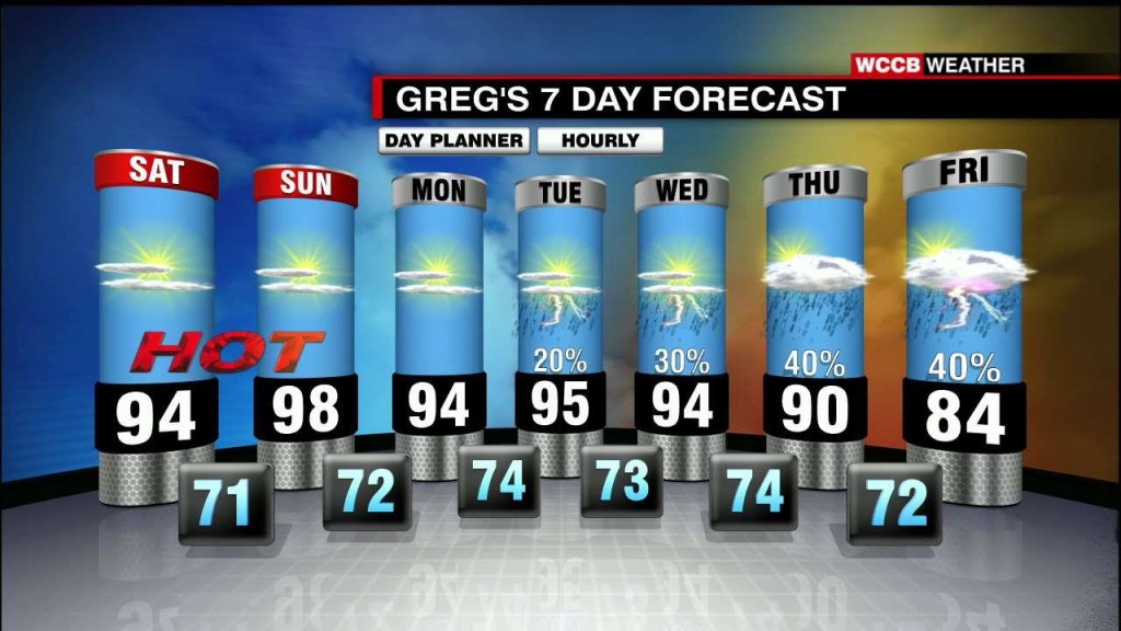
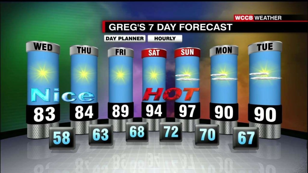
[gtxvideo vid="N8WHXKly" playlist="" pid="XkGI5ukr" thumb="http://player.gtxcel.com/thumbs/N8WHXKly-120.jpg?cachebust=1465612765747" vtitle="6-10-2016 GREG 10PM WX"] Sunny And Hot Weekend, Isolated Storm Chance Saturday and Sunday will be hot and muggy with highs in the mid 90s. A few locations may reach 100° Sunday afternoon. Mostly sunny…
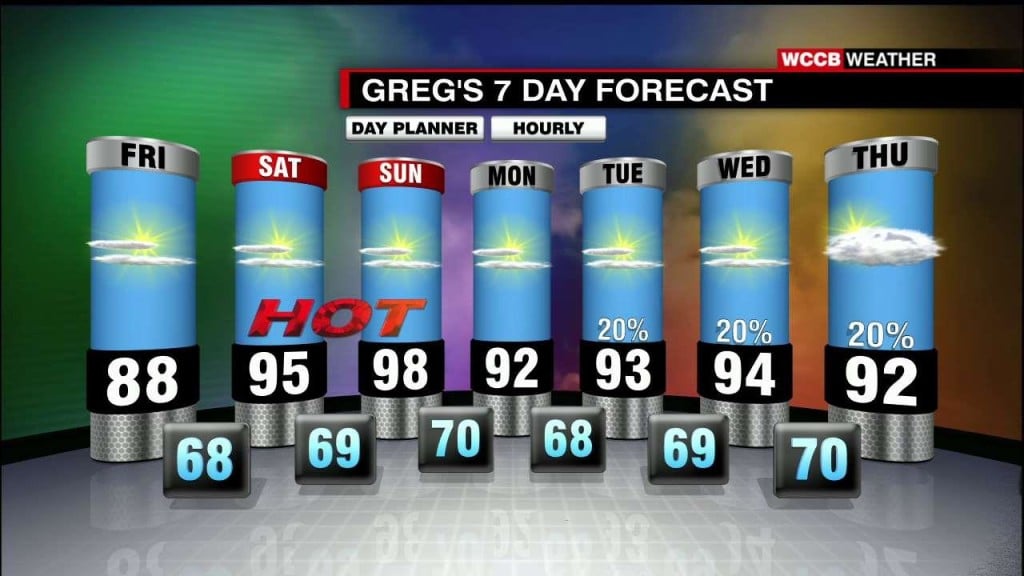
[gtxvideo vid="S0OzOpHs" playlist="" pid="XkGI5ukr" thumb="http://player.gtxcel.com/thumbs/S0OzOpHs-120.jpg?cachebust=1465526250559" vtitle="6-9-2016 GREG 10PM WX"] Warming Trend Into The Weekend, Continued Dry The heat will begin to build Friday with highs near 90° under mostly sunny skies. Saturday and Sunday will be hot and muggy with…
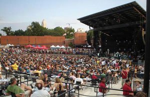
Ellie Goulding and R. Kelly are scheduled to perform in the Queen City on Thursday evening, and the weather is looking pretty nice.
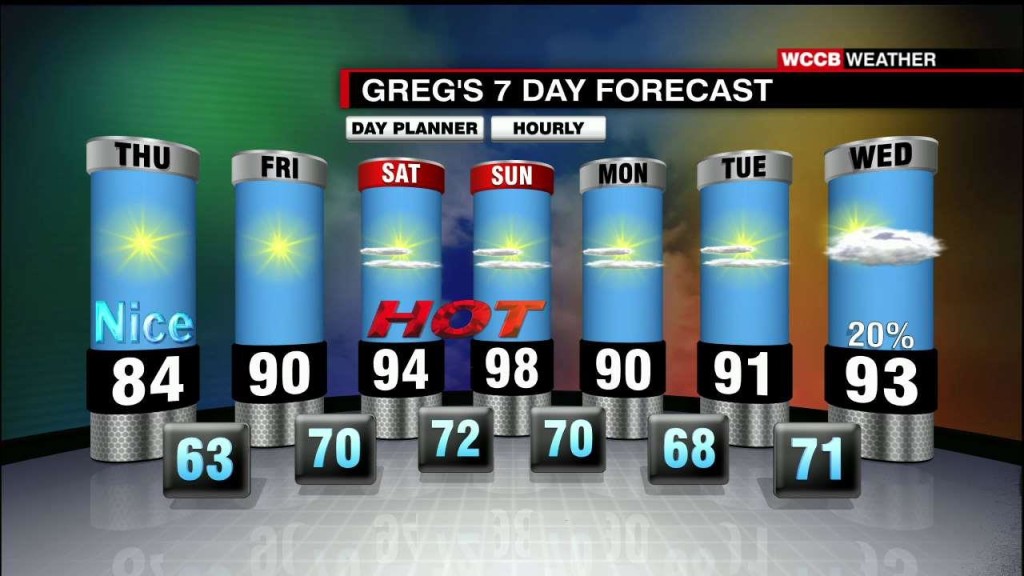
[gtxvideo vid="bwY11hE9" playlist="" pid="XkGI5ukr" thumb="http://player.gtxcel.com/thumbs/bwY11hE9-120.jpg?cachebust=1465440024546" vtitle="6-8-2016 GREG 10PM WX"] Sunny And Comfortable Through Thursday, Hot Weekend Thursday will be a beautiful day with highs in the low to mid 80s under mostly sunny skies. The heat will begin to build…
[gtxvideo vid="n7iPRGIu" playlist="" pid="XkGI5ukr" thumb="http://player.gtxcel.com/thumbs/n7iPRGIu-120.jpg?cachebust=1465353678510" vtitle="6-7-2016 GREG 10PM WX"] Sunny And Comfortable Through Thursday, Heat Builds Into The Weekend Sunshine will dominate Wednesday and Thursday with low humidity and afternoon highs in the low 80s. Temperatures will begin to warm…
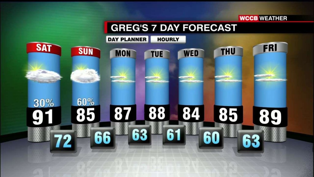
[gtxvideo vid="L24pbG9p" playlist="" pid="XkGI5ukr" thumb="http://player.gtxcel.com/thumbs/L24pbG9p-120.jpg?cachebust=1465008073051" vtitle="6-3-2016 GREG 10PM WX"] Warm And Muggy, Scattered Storms Through The Weekend Saturday will be another warm and muggy day with high in the upper 80s to low 90s, hit and miss storms during the…
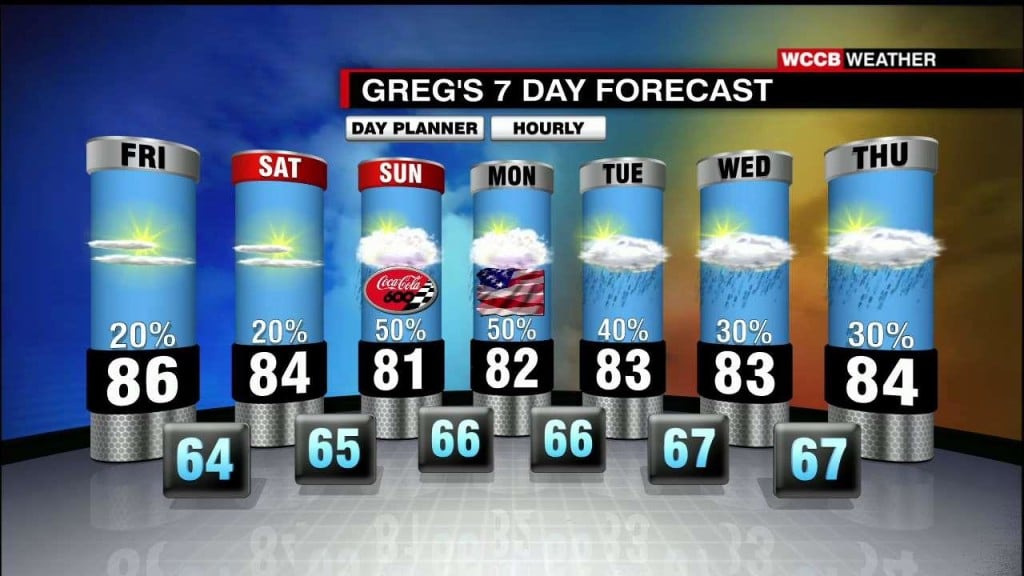
Unsettled weather continues for the end of the week and through the weekend.
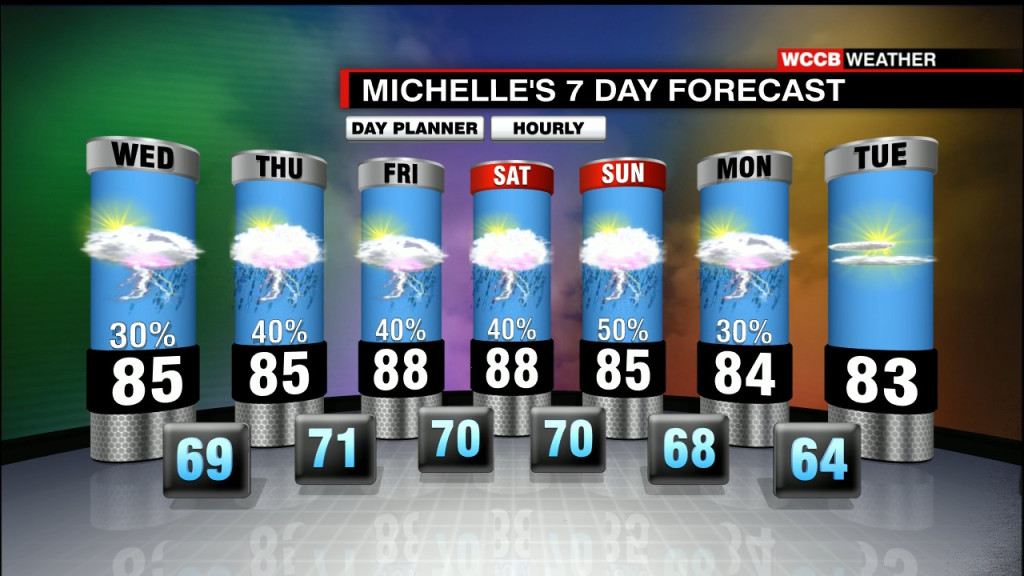
Rain chances stay in the forecast for the next several days.
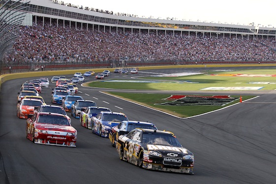
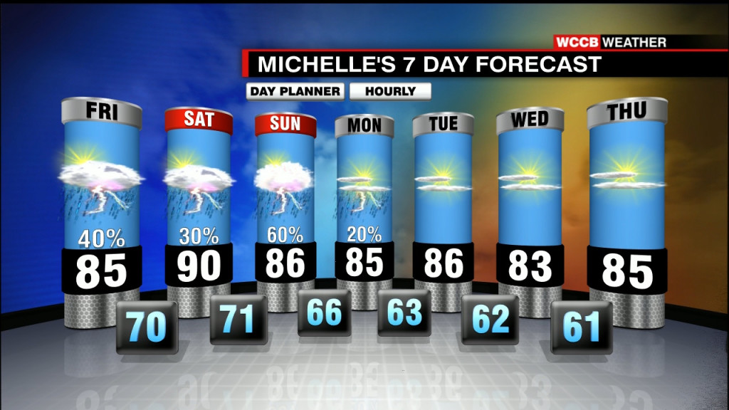
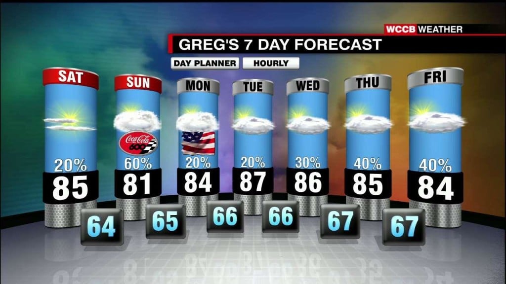
Rain chances pick up for the second half of the weekend, which could impact the Coca-cola 600.
[gtxvideo vid="k9HhSKRD" playlist="" pid="XkGI5ukr" thumb="http://player.gtxcel.com/thumbs/k9HhSKRD-120.jpg?cachebust=1464403265154" vtitle="5-27-2016 GREG 10PM WX"] Rain Chances Increase Over The Holiday Weekend Saturday will be a warm and muggy day with highs in the mid 80s under a mix of sun and clouds. There is a…
[gtxvideo vid="pj8qXE0u" playlist="" pid="XkGI5ukr" thumb="http://player.gtxcel.com/thumbs/pj8qXE0u-120.jpg?cachebust=1464316817989" vtitle="5-26-2016 GREG 10PM WX"] Continued Warm And Muggy, Scattered Storms Each Afternoon Friday and Saturday will be warm and humid with highs in the mid to upper 80s under a mix of sun and clouds.…
The 22nd annual Speed Street forecast is looking pretty nice and warm.
[gtxvideo vid="TJecqh2p" playlist="" pid="XkGI5ukr" thumb="http://player.gtxcel.com/thumbs/TJecqh2p-120.jpg?cachebust=1464144017156" vtitle="5-24-2016 Greg 10pm WX"] Above Average Temperatures This Week, Slim Rain Chances Wednesday and Thursday will be warm and slightly more humid with highs in the mid to upper 80s. Mostly sunny skies are expected…
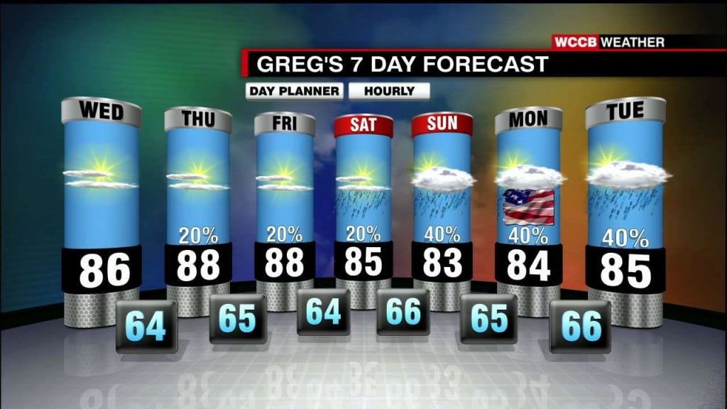
Cloudy skies with showers will stay in the forecast through part of Saturday.
[gtxvideo vid="Q7UrN2JL" playlist="" pid="XkGI5ukr" thumb="http://player.gtxcel.com/thumbs/Q7UrN2JL-120.jpg?cachebust=1463798142571" vtitle="5-20-2016 GREG 10PM WX"] Wet Start To The Weekend, Gradual Improvement Sunday It will be a wet start Saturday with gradually improving conditions as the day progresses, highs in the mid 70s. Although a lingering…
