Scattered heavy rain continues to fall today. Thunderstorms have rolled through the area as well. Flood watches have been upgraded to warnings for the Piedmont, and the Foothills through 5:15 pm.
Rainfall rates up to 3-4 in/hour have been reported. Nearly 3″ of rain measured in Mecklenburg County with an additional 1-2″ possible by tonight. Strong winds possible with any thunderstorm that develops today.
Chester, and Lancaster Counties have already experienced gusts at 60 mph plus. Downed trees, and power lines are possible due to the saturated soil. If you hear thunder, move indoors. Do not try to drive through standing water, because it is probably deeper than it appears.
The good news is, the rain will be getting lighter soon. Recent models are showing the rain dwindle by 3pm. Scattered light rain will be possible through the morning.
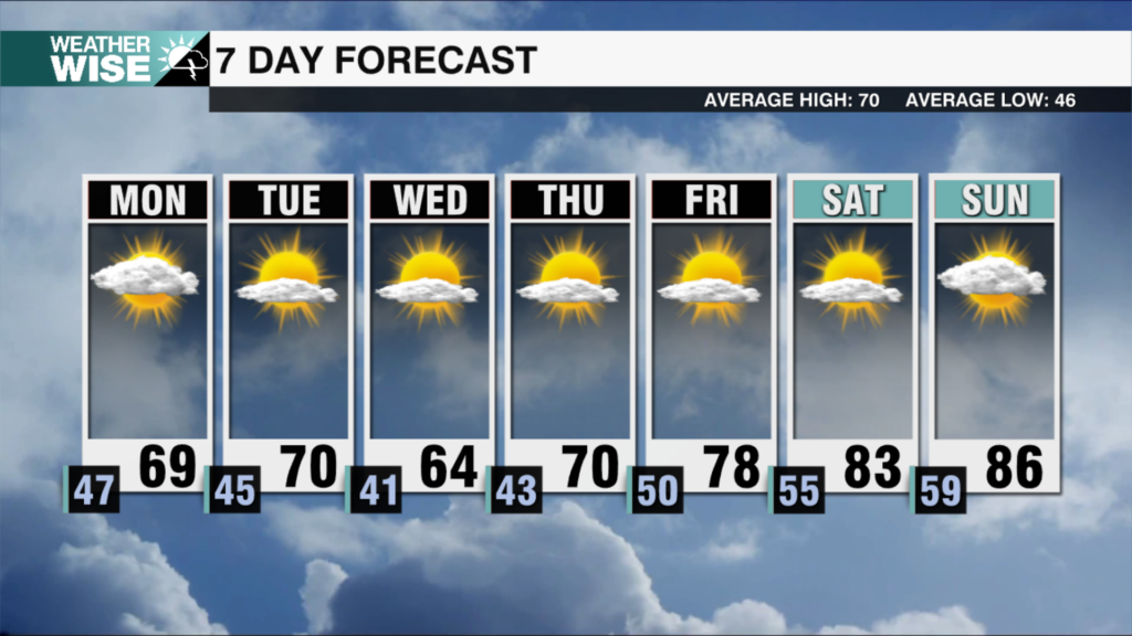
Drying, and clearing this weekend! Cooler temperatures will be on the way as well, with highs in the 50s.
See flood photos HERE
Flooding video on Hambright Rd at Beatties Ford Rd. Slow down & Look for @HPDNC directing traffic. #clttraffic pic.twitter.com/Dlbew2atiq
— Huntersville Fire (@Huntersville_FD) December 30, 2015
High water along Greenway behind Cedarfield. AVOID the Greenway completely. Expecting more rain over next few hrs pic.twitter.com/VrsMokHaOF
— Huntersville Fire (@Huntersville_FD) December 30, 2015
Waxhaw under flash flood warning til 5:45 pm. 12 Mile Creek near Kensington/Waxhaw-Marvin Rd rising & running fast. pic.twitter.com/fUa6qFF8ng
— Town of Waxhaw (@TownofWaxhaw) December 30, 2015