Ida Forecast to Become a Major Hurricane Before Landfall this Weekend
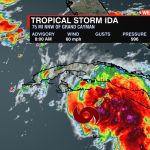
We are entering peak hurricane season and the tropics are active. Two storms are being watched in the Atlantic, but it’s Tropical Storm Ida that has all of our attention at this time. As of the 8am Update from the National Hurricane Center Ida is strengthening with sustained winds of 60 mph and will become a hurricane later today as it enters into the Gulf of Mexico. From there it will be moving into very warm waters and low shear. This will fuel the storm and provide an environment for it to rapidly intensify.
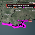
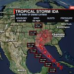
Ida is forecast to strengthen into a Major Category 3 hurricane by Sunday. A hurricane watch is in effect from Cameron LA to the Missippi border. A Tropical Storm Watch extends to the Florida Panhandle. As of the latest model trends, the track of Ida has shifted slightly more east which keeps New Orleans in the direct path of this storm. Significant storm surge, Intense winds and flooding rain, as well as embedded tropical tornadoes, will be possible. Impacts will begin along the LA/MS coast Saturday with landfall late Sunday into Monday.
Ida will slowly move through Louisiana bringing several inches of rain to the state. It will move into Central Tennesse and then steer east towards the Carolinas. There is still a high level of uncertainty with exact impacts for the Carolinas, but preparing for steady and at times heavy rain will be a good bet Wednesday and Thursday.
For the most up-to-date information, download the WCCB Weather App Powered by COIT.


