Isolated Strong Storms Possible Overnight
Have at least two ways to receive warnings
We are now in an unsettled pattern with several opportunities for measurable rain through the weekend. A springlike pattern will also bring the risk for isolated strong storms. Rain and storm chances will increase this evening with all modes of severe weather possible. Our severe risk is low, but not zero – the primary threat will be damaging wind. With a broken line moving through during the evening and overnight hours many will be sleeping so be sure you have at least two ways to receive warnings. Another round of showers and storms will move through Thursday afternoon. This too will bring the risk for isolated strong storms.
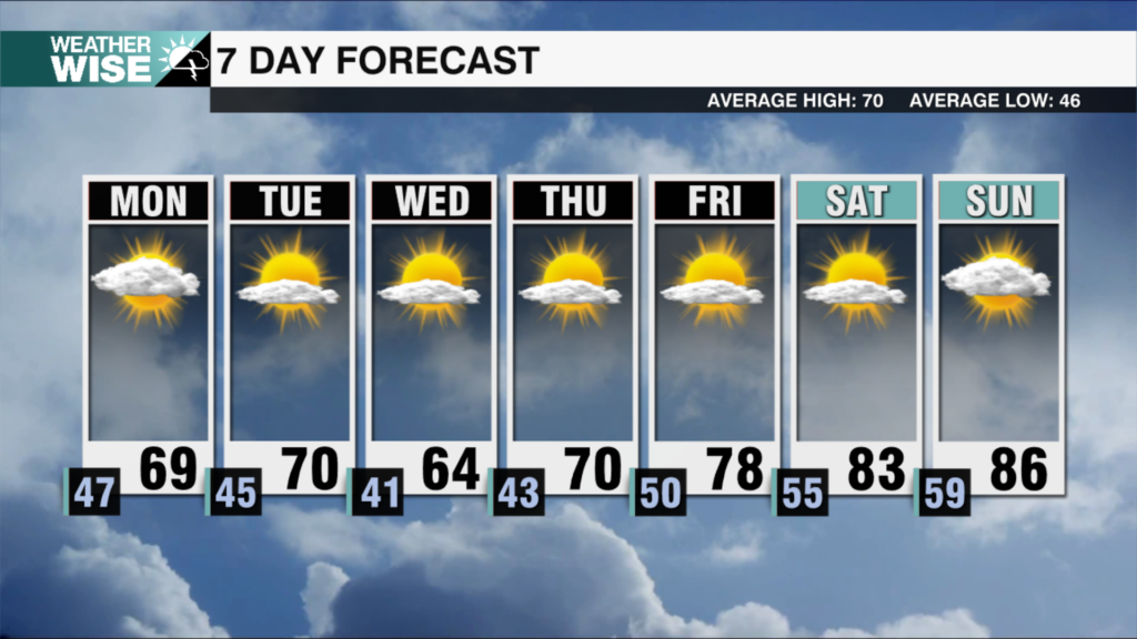
Temperatures will stay well above average with highs in the 70s through the week. Winter makes a comeback behind a strong cold front that will move through on Sunday. High temperatures on Monday will only top out in the upper 40s.
Tonight: Scattered showers. Isolated storms. Patchy fog. Low: 64. Wind: S/SW 5-15.
Thursday: AM patchy fog. Scattered showers. Isolated storms. High: 74. Wind: SW 10-20.
Friday: Partly sunny. PM showers. High: 74. Wind: SW 5-10.
Have a great Wednesday and stay weather aware for the next 24 hours!
Kaitlin