Winter Weather Alert: More Mountain Snow, Tumbling Temps
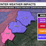
CHARLOTTE, N.C. — Who’s ready for round two? Another quick-hitting system sweeps into the Carolinas Thursday afternoon and evening, bringing another batch of rain and snow along with it. Winter Weather Alerts are in effect for our mountain communities.

High Country

WHAT TO EXPECT:
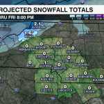
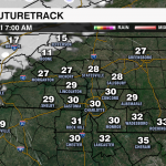
A Winter Weather Alert is in effect through Friday morning for Ashe, Avery and Watauga counties. This should largely be a snow event for our mountains, but communities around 3500′ may see a bit of a wintry mix to start as moisture moves in by 4 PM Thursday. All High Country locations should see snow by 7 PM. Snow will gradually cease from southwest to northeast before sunrise, although northwesterly flow could lead to flurries through 7 AM Friday. Unlike Monday’s winter storm, there isn’t as much moisture to work with making for fluffier flakes lower snowfall totals. Snow totals will top out around 1-3″, for locations above 3500′, with up to 4″ for the highest elevations above 5000′.
IMPACTS:
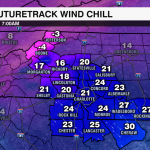
Temperatures will remain below freezing shortly after the onset of the precipitation, which could make for slippery travel. Bitter cold settles in Friday morning, as temperatures bottom out in the teens. Winds will be out of the northwest at 10-20 mph with gusts up to 40-45 mph. This will bring wind chills down to the single digits, if not below zero. It won’t get much better during the day with highs only reaching the low to mid 20s. If you’re planning a weekend trip to the mountains, prepare for the cold with plenty of layers, goggles, and a face mask to stay warm. Saturday will be cold, but sunny with calmer winds and highs in the mid 30s.
Foothills/Northern Piedmont
WHAT TO EXPECT:
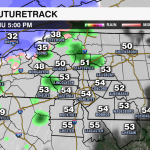
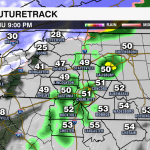
Sorry, snow-lovers! This likely won’t be the system for you. Cold air will be chasing the moisture and there’s a very low chance there will be any flakes mixing in with the snow outside of the northern foothills. Scattered rain showers will move into the region after 7 pm. Rain will continue for the next few hours before tapering off west-to-east by midnight. Temps will still be in the mid to upper 40s at this time, but will drop quickly into the upper 20s to lower 30s near daybreak.
IMPACTS:
Unlike our last system, strong winds will not be an issue. But, even a light breeze with this very dry air mass will make it feel like the teens and 20s early Friday morning. Roads will be wet overnight, and with temperatures hovering near freezing Friday morning, black ice is squarely within the realm of possibility. Take it easy on the roads for your Friday morning commute. Daytime highs will only reach the low 40s, but it will feel like the low 30s for much of the day.
Metro/Southern Piedmont
WHAT TO EXPECT:
Rain, rain, and more rain. With temperatures in the mid-40s, it’ll be quite the stretch to see anything remotely wintry around the Charlotte area. Scattered showers will begin shortly after sunset and will continue off-and-on before tapering off west-to-east by the early morning hours on Friday. Some spots south of the Metro may be limited to a few isolated showers or even nothing at all. A flurry or two is possible north and east of the Queen City as the rain moves out, but no accumulations are expected.
IMPACTS:
The bigger story for many of us around the Metro will be the cold air. With some spots waking up in the 20s Friday morning, patchy black ice could form in areas that don’t completely dry out overnight. Major impacts are not expected, but drive carefully and watch your speed. Remember to bring your pets inside overnight and pull out the heavy winter jacket. Temps won’t get out of the 40s Friday, but it will be feeling like the low 30s at its warmest during the late afternoon.


