Watching the Tropics
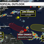
The National Hurricane Center is watching four areas in the Atlantic for potential development over the next few days. One of which has a high likelihood of becoming a tropical depression before the week is through.

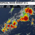
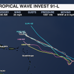
The first area with the highest potential for development is located in the Central Atlantic. As of Monday morning, the tropical wave is still poorly disorganized. It will move slowly through mid-week before accelerating off to the northwest by Friday. Conditions are only moderately favorable as this disturbance fights through high shear over the next few days. However, models are in good agreement with the initial track of this storm staying north of the Lesser Antilles into better conditions for strengthening later this week. As of now, it is also likely to become a tropical depression by Friday and could strengthen further this weekend. As of now, models are trending that this storm would stay out to sea, as a trough protects the east coast. This will curve the storm north and gradually east – away from the southeast. However, remember things can change, so this will be something to watch in the coming days.

The next area to watch is north of the first and has a low chance of development in the next few days. Strong upper-level winds and dry air will limit any significant development. It will likely dissipate before the week is through.
Gradual development will be possible in the Eastern Atlantic off the African coast at the start of September. Warm water temperatures, moisture, and low shear would aid in providing a good environment for development through the first week of the new month.
The final area to watch is within the Northwest Caribbean. An area of low pressure could develop late week. Environmental conditions would support gradual development.
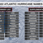
The next name on the 2022 Atlantic Hurricane List is Danielle.

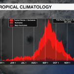
There has not been a named storm in the Atlantic since early July. If no storms are named by Wednesday, it would be the first time since 1997, that a storm hasn’t formed in the Atlantic during the month of August.
Although the season has been quiet, it does not mean that it will stay that way. The National Hurricane Center is still forecasting an above-average season. The most active month for hurricane season is September with the peak of the season coming in a few weeks on September 11.