Post Tropical Cyclone Idalia Pulls Away From The Carolinas


Idalia has lost tropical characteristics, therefore is now a Post-Tropical Cyclone. As of the 11 PM advisory Thursday evening, Post-Tropical Cyclone Idalia has winds of 65 mph and continues to race to the east at 23 mph.

Tropical Storm Watches have been issued for Bermuda as Idalia moves toward the island.
Idalia made landfall around 7:45 AM Wednesday as a strong category 3 hurricane along Florida’s Big Bend with winds of 125 mph. Idalia brought devastating storm surge to Florida’s coast, confirmed tornadoes across the Carolinas along with significant flooding to parts of the southeast.
Confirmed Tornadoes From Idalia Across The North Carolina & South Carolina Coast:
- A waterspout moved ashore in Wilmington and became a tornado along Myrtle Grove Road. The National Weather Service storm survey found max wind speeds of 100 mph making this an EF1.
- Brunswick County: An EF0 tornado has been confirmed in St. James with estimated winds of 80 mph.
- EF-0 tornado damage found in Mt Pleasant, South Carolina, but the storm survey is still ongoing.
- Confirmed tornado in Goose Creek. This is the one that flipped the car on the highway.
- Storm surveys will be released soon from Georgetown County, SC (near Pawley’s Island) & from Horry County, SC (Cherry Grove area).
PREVIOUS UPDATE 5AM 8/31
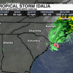
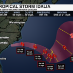
As of the 5am update from the National Hurricane Center, Idalia remains at tropical storm strength off the coast of Wilmington. Sustained winds are at 60 mph with gusts up to 70 mph. As the storms sits over open water, it will continue to drop heavy rain across Carolinas Coastal Communities.

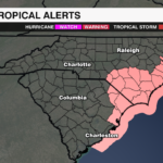
Tropical Storm Warnings remain in place for the east coast of North and South Carolina. Gusts 50-60 mph will still be possible through Thursday.
Rain will slowly clear the coast through the evening, but an additional 2-3″ will be possible for eastern North Carolina.

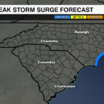
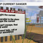
Storm surge 3-5′ will remain a threat for parts of the Outer Banks. Even as Idalia moves away from the east coast, a strong rip current risk will remain for our Carolina Beaches. Something to keep in mind for any Labor Day beach goers.

Locally, rain has ended across the region and the clouds are beginning to thin. Breezy for the first half of the day with gusts 20-30 mph still possible. Winds will be out of the NE as cooler drier air settles into the region. Dry and pleasant well into next week.
PREVIOUS UPDATE 11PM 8/30
Idalia made landfall around 7:45 AM Wednesday as a strong category 3 hurricane along Florida’s Big Bend with winds of 125 mph. Idalia brought devastating storm surge to Florida’s coast, confirmed tornadoes across the Carolinas along with significant flooding to parts of the southeast.
As of the 10 PM advisory from the National Hurricane Center, Idalia is just north of Charleston, South Carolina with winds of 60 mph. This storm is still moving very quickly to the northeast at 21 mph.
Locally, rain will continue mainly southeast of I-85 over the next couple of hours. By 4 AM, most of the rain will be out of the WCCB Charlotte area. Clouds will decrease early Thursday morning with a breeze still hanging around through the morning hours. Lower humidity builds in through the day with a beautiful end to the week.
PREVIOUS UPDATE 12PM 8/30
Idalia is weakening as it moves rapidly into South Georgia. It is now a category 1 hurricane with sustained winds of 85 mph as of the noon update from the National Hurricane Center. Impacts remain across the southeast, however. Life-threatening storm surge, inland flooding, damaging wind gusts, and isolated tropical tornadoes will all continue to be threats through early Thursday.

Tropical Storm Warnings are in effect across the Carolina coast where conditions will deteriorate over the next few hours with 50-60 mph gusts likely closest to the coast. Storms surge up to 5 feet will be possible for parts of the Low Country. This will lead to beach erosion ahead of the Labor Day Weekend. However, conditions will improve for holiday travelers as the storm will clear the coast by Thursday afternoon.

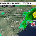
The lingering threat will be residual flooding. Any flash flooding from heavier rain bands will need to move from streams and creeks to larger rivers. This could keep tributaries and rivers at elevated levels through the weekend depending on where the heaviest rain falls. Rainfall totals of 4-8″ are still possible across the Eastern Carolinas.

Local threats remain the same. The outer rain bands are now reaching the region. A flood watch goes into effect for areas south and east of I-85 at 2pm and continues through Thursday. Rainfall totals of 1-3″ will be possible. Remember if you come across a flooded roadway, turn around and find an alternate route and never go around barricades. Wind gusts of 20-30 mph will be possible, but the strongest gusts will be closer to the center of the storm, near the coast.

For the latest updates on the tropics and Hurricane Idalia, download the WCCB Weather App.
PREVIOUS UPDATE 9AM 8/30
Idalia made landfall along the Big Bend Region of Florida near Keaton Beach at 7:45 a.m. Wednesday as a strong Category 3 hurricane. Sustained winds were at 125 mph with a central pressure near 749 MB. It is the strongest storm to make landfall along this part of the Florida coast on record.

The storm briefly strengthened overnight to a category 4 hurricane before beginning an eyewall replacement cycle shortly before landfall.
As of 9 a.m., the storm has sustained winds of 110 mph and a central pressure of 957 MB. A wind gust of 85 mph was reported from the Perry Airport.
Catastrophic storm surge is ongoing with up to 16′ of storm surge possible for parts of the Florida Coast with damaging hurricane-strength winds expanding inland.

Idalia will slowly weaken as it crosses into southern Georgia this afternoon. The center of the storm will slide along the Carolina coast overnight into early Thursday before moving offshore and into the Atlantic Thursday afternoon.

Inland flooding also remains a concern with 4-8″ of rain possible from North Florida to Southern Georgia and the Eastern Carolinas.

A Hurricane Warning remains in effect for portions of northern Florida, Southern Georgia, and Southeastern South Carolina. Tropical Storm Warnings are in effect for the Carolina coast with Tropical Storm Watches in effect as far inland as Columbia.
Storm surge of 4-6′ will be possible for parts of the South Carolina coast. Tropical Storm conditions will begin for parts of the Carolina coast later today. Gusts exceeding 50 mph will be possible for areas near the coast.

Local impacts will begin this afternoon. A flood watch is in effect from 2pm through midday Thursday for areas near and south and east of I-85. Rainfall totals of 1-3″ will be possible with higher totals for communities closer to the coast.
Although the strongest gusts as forecast near the center of the storm, gusts 20-30 mph will likely for parts of the Piedmont this evening through early Thursday.
Download the WCCB Weather App for the latest updates on Idalia and what you can expect locally.
PREVIOUS UPDATE 11pm 8/30
The Hurricane Hunters have found that Idalia is continuing to strengthen. As of the 11 PM National Hurricane Center update, Idalia is nearing category 3 strength with winds of 110 mph. 
The new 11 PM update also shows a category 4 hurricane when Idalia makes landfall along the Big Bend of Florida. Impacts remain the same with life threatening storm surge, flash flooding, and damaging wind gusts the greatest threats across Northern Florida, Southern Georgia and the Carolina Coast. The greatest threat from Hurricane Idalia will be storm surge along Florida’s Big Bend. Surge is forecast to reach 10-15′. This will be catastrophic. 2-4′ storm surge is forecasted along the Carolina coast.

Flash flooding will also be a big concern across the southeast. Flash flooding could be significant and is expected across portions of Florida and Southern Georgia Tuesday into Wednesday. The threat of flash flooding will extend across the Coastal Carolinas Wednesday into Thursday. Rainfall totals of 4-8″ will be possible from the Florida Panhandle to Southern Georgia and the Eastern Carolinas. Isolated totals up to 12″ will be possible across North Florida.
Although the main impacts will be felt across the Carolina coast, local conditions will begin to get breezy Wednesday night into Thursday morning as the pressure gradient tightens with high pressure over the midwest and Idalia inching up the Carolina coast. Some of the outer rain bands could bring up to an additional inch to two inches of rain for areas south and east of I-85.
Stay up to date with the latest on Hurricane Idalia and the tropics by downloading the WCCB Weather App.
PREVIOUS UPDATE 5AM 8/29
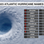
As of the 5 a.m. update from the National Hurricane Center, Idalia has strengthed into a category 1 hurricane. It is the 3rd hurricane of the 2023 Atlantic Hurricane Season and is on track to become the 2nd major hurricane before making landfall along the Florida Gulf Coast Wednesday.

The biggest change with this update is a slightly slower track and a slight shift to the west. Impacts remain the same.

Idalia will rapidly intensify over the next 24 hours. It will strengthen into a major category 3 hurricane off the northern gulf coast of Florida Wednesday morning. The track has shifted a little further to the north and west but continues to eye the Big Bend region of Florida Wednesday morning.

Hurricane warnings are in effect from the northern Florida Gulf Coast to the middle of Longboat Key. Hurricane conditions will begin late today into early Wednesday for those under the hurricane warnings with tropical storm conditions beginning today. Tropical Storm Watches now extend along the South Carolina coast as far north as the South Santee River. Tropical Storm conditions will begin across East Florida and for the Carolina Coast on Wednesday.

Life-threatening storm surge will be one of the greatest threats of this storm. Storm surge of 8-12 feet will be possible along the Big Bend Region of Florida with up to 6 feet of storm surge along the South Carolina Coast.

Flash flooding will also be a big concern across the southeast. Flash flooding could be significant and is expected across portions of Florida and Southern Georgia Tuesday into Wednesday. The threat of flash flooding will extend across the Coastal Carolinas Wednesday into Thursday. Rainfall totals of 4-8″ will be possible from the Florida Panhandle to Southern Georgia and the Eastern Carolinas. Isolated totals up to 12″ will be possible across North Florida.
Stay up to date with the latest on Hurricane Idalia and the tropics by downloading the WCCB Weather App.
PREVIOUS UPDATE 8PM 8/28
As of the 8 p.m. update from the National Hurricane Center, Idalia is battling wind shear and is still at tropical storm strength. Unfortunately, this will not be the case for long.  Idalia is forecast to rapidly intensify in the eastern Gulf of Mexico before making landfall along the northeastern Gulf Coast early Wednesday.
Impacts to the WCCB Charlotte area will vary and depend on the final track:
- If the center of Idalia tracks a bit inland from the immediate coast, this will result in higher rain chances southeast of I-85.
- If the center of Idalia tracks just offshore, rain chances will not be as high for those southeast of I-85.
- We will be on the “better” side of this storm, therefore, will not see a tornado threat.
 Rain totals will be highest closest to the coast. Totals ultimately depend on the final track, but most neighborhoods in our area can expect 1-3” of rain.
Impacts to Florida:
- The wind could of course and will likely cause damage, but the water is the main threat. Due to the storm strength, shape of the coastline and the angle of approach, some areas along the Florida coast will likely see a storm surge of 8+ feet.

PREVIOUS UPDATE: 8/28 AM
As of the 8 a.m. CST update from the National Hurricane Center, Tropical Storm Idalia is forecast to strengthen into a hurricane late Monday. It will rapidly intensify into a major category 3 hurricane over the northeastern Gulf of Mexico by early Wednesday. This will be the third hurricane and the second major hurricane of the 2023 Atlantic Hurricane season.

Current model trends have Idalia making landfall along the Nature Coast of Florida by Wednesday morning as a major category 3 hurricane. Impacts from Idalia will begin for the west coast of Florida as early as late Tuesday evening.
The storm is forecast to move quickly into Southern Georgia after cutting across the Florida Peninsula. It will move along the South Carolina Coast Wednesday night into Thursday morning, where it is forecast to remain a tropical storm before moving away from the North Carolina coast and into the Atlantic through Thursday evening.

This track keeps the greatest impacts of this storm closer to the Carolina coast and away from the WCCB viewing area. However, any further progression to the west could bring an even greater flooding threat locally.
Hurricane Watches are currently in effect from the Big Bend Region of Florida south through Tampa with Tropical Storm Warnings in effect for the Southern Gulf coast of Florida from Ft Myers to Naples.

Storm Surge Watches are also in effect with life-threatening storm surge up to 7-11′ possible for parts of the Florida Gulf Coast.

Flash flooding will also be a big concern across the southeast. Flash flooding could be significant and is expected across portions of Florida and Southern Georgia Tuesday into Wednesday. The threat of flash flooding will extend across the Coastal Carolinas Wednesday into Thursday. Rainfall totals of 4-8″ will be possible from the Florida Panhandle to Southern Georgia and the Eastern Carolinas. Isolated totals up to 12″ will be possible across North Florida.

Stay up to date with the latest on Idalia and the tropics with the WeatherWise team by downloading the WCCB Weather App.
PREVIOUS UPDATE: 8/26
The Carolinas are bracing for their first visit from the tropics in 2023.
Tropical Depression Ten, formerly known as Invest 93L, has formed in the extreme northwest Caribbean and now has the Southeast in its sights. As of 5 PM Saturday, the fledgling system has 30 miles per hour winds and is sitting just to the east of the Yucatán Peninsula.

While Ten won’t move much over the next 48 hours, it will eventually pick up the pace towards the north, likely coming ashore over Florida by midweek as Idalia. The Carolinas are squarely within the National Hurricane Center’s (NHC) forecast cone for the system.

There is still a lot of uncertainty about future Idalia’s strength and exact track, but odds are increasing that the Carolinas will see *some* sort of impact from the system. Regardless of Idalia’s future, a boatload of rain is heading toward the Palmetto and Tar Heel States. Most communities in the WCCB can safely expect at least 1-2″ over the next seven days.


